The Radar Altimeter Database System (RADS) was developed by the Delft Institute for Earth-Oriented Space Research, the NOAA Laboratory for Satellite Altimetry, and EUMETSAT. RADS provides a suite of tools or utilities that simplify the reading, editing and handling of data from multiple satellite radar altimeters. These tools abstract the user from having to work directly with the NetCDF datasets. Updates and corrections usually are performed to the data files, allowing the software tools to remain unchanged.

Overview
The Radar Altimeter Database System (RADS) was developed by the Delft Institute for Earth-Oriented Space Research, the NOAA Laboratory for Satellite Altimetry, and EUMETSAT. RADS provides a suite of tools or utilities that simplify the reading, editing and handling of data from multiple satellite radar altimeters. These tools abstract the user from having to work directly with the NetCDF datasets. Updates and corrections usually are performed to the data files, allowing the software tools to remain unchanged.
![]()
The Radar Altimeter Database System is composed of three elements:
- Database: ~700GB gigabytes of altimeter data files (routinely synchronized)
- Software Utilities: A set of software tools (object library and executables);
- Configuration files: XML file used to describe altimeter missions, variables, and interim variables
Once the files, software, and configuration files are local to the user's system, setup of the environmental variables is required prior to using the system.
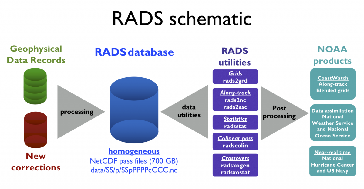
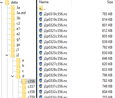
Data Files
RADS data are a collection of NetCDF files, each containing about a half-orbit (ascending/descending) of satellite data. The collection includes data from both past and current satellite missions and are updated twice per day by NOAA and EUMETSAT. The up-to-date set of files is what is referred to as the database.
The satellite pass files are stored as NetCDF with Climate Forecast conventions. Data parameters are dimensioned as a time-based trajectory and typical file-size varies between about 400KB to 1MB. Filenames include abbreviated satellite name, pass number, and cycle number (SSpPPPPcCCC.nc). Passes are sequential, assigning ascending passes with odd numbers and descending with even. These reset each cycle.
Data files are organized into directories for each cycle, which are then grouped for each mission phase for each spacecraft:
Abbreviated satellite names are listed below along with the mission dates. An absent end date indicates an active mission.
| ID | Satellite (Mission) | Dates |
|---|---|---|
| gs | Geosat | 1985-1989 |
| e1 | ERS-1 | 1991-1996 |
| tx | TOPEX | 1992-2006 |
| pn | Poseidon | 1992-2006 |
| e2 | ERS-2 | 1995-2011 |
| g1 | GFO | 1998-2008 |
| n1 | Envisat | 2002-2012 |
| j1 | Jason-1 | 2001-2013 |
| j2 | Jason-2 | 2008-2020 |
| c2 | Cryosat-2 | 2010- |
| sa | SARAL/Altika | 2013- |
| j3 | Jason-3 | 2016- |
| 3a | Sentinel-3A | 2016- |
| 3b | Sentinel-3B | 2018- |
Mirroring the Database
The RADS database is available from several mirrors. NOAA hosts a mirror at ftp://ftp.star.nesdis.noaa.gov/pub/sod/lsa/rads/data/.
These data are updated twice daily and should regularly be checked for updates. Various tools can be used to mirror the data holdings such as curl, wget, or lftp.
An example using lftp:
$ lftp ftp://ftp.star.nesdis.noaa.gov/pub/sod/lsa/rads/data/cd ok, cwd=/pub/sod/lsa/rads/datalftp ftp.star.nesdis.noaa.gov:/pub/sod/lsa/rads/data> mirror --only-newer `3ap0530c001.nc' at 603288 (99%) [Receiving data]
Software Utilities
The requirements to compile and run the code are:
- A unix-type environment (Linux, macOS, etc.).
- The make command.
- A fortran compiler (preferrably gfortran, but others like f90, f95, xlf90, xlf95 and ifort are known to work as well)
- The NetCDF library (version 4.3 or later, compiled) and together with the Fortran 90 interface and module file.
- Optionally, the git program.
- For downloading and synchronizing the data base: the rsync or lftp.
Updated code and documentation are hosted on GitHub: https://github.com/remkos/rads♦
Examples
The following examples illustrate the potential of the RADS utilities.
- List the variable names for a mission (Satellite/sensor)
- Command: radsvar
- Options: -S<satellite/mission code>/<mission phase>
- Example: radsvar -Sj3
Output:
# RADS variable list # Created: 2020-06-17 21:40:21 UTC: radsvar -Sj3 # # Possible output records: # A field alias var_name long_name # D field var_name default_value long_name # G field var_name grid_file_name long_name # M field var_name math_rpn_statment long_name # N field var_name netcdf_var_name long_name # M 0 sla alt range SUB dry_tropo SUB wet_tropo SU sea level anomaly M sla_mle3 alt range_ku_mle3 SUB dry_tropo SUB wet_ sea level anomaly (MLE3) N ssha ssha sea surface height anomaly N ssha_mle3 ssha_mle3 sea surface height anomaly (MLE3) M adt sla mss ADD geoid SUB absolute dynamic topography N 1 101 time time time M 102 time_rel_eq time eqtime SUB time relative to equator crossing M 103 time_local_solar time lon 240 MUL ADD 86400 FMOD local solar time of day M 104 time_ymdhms time YMDHMS time M 105 time_mjd time 86400 DIV 46066 ADD Modified Julian Days M 106 time_2000 time 473299200 SUB time M time_1950 time 86400 DIV 12784 ADD time N 2 201 lat lat latitude N 3 301 lon lon longitude N 425 alt_gdre alt_gdre CNES GDR-E orbital altitude A 4 alt alt_gdre CNES GDR-E orbital altitude N 5 501 alt_rate alt_rate orbital altitude rate N 601 range_ku range_ku Ku-band range corrected for instr. effects A 6 range range_ku Ku-band range corrected for instr. effects N 602 range_c range_c C-band range corrected for instr. effects ...- Example: radsvar -Sj3 -Vdry_tropo
Output:
# RADS variable info
# Created: 2020-06-17 21:40:28 UTC: radsvar -Sj3 -Vdry_tropo
#
userroot="/"
dataroot="/rads/share"
sat="j3"
branch="j3"
phase="a"
satellite="JASON-3"
cycles=(0 999 1)
passes=(1 254 1)
alias="dry_tropo"
var="dry_tropo_ecmwf"
long_name="ECMWF dry tropospheric correction"
units="m"
data="dry_tropo_ecmwf"
source="ECMWF"
comment="A dry tropospheric correction must be added to range to correct for dry troposphere delays"
limits=(-2.4000 -2.1000)
plot_range=(-2.4000 -2.2000)
diff_range=(-.1000 .1000)
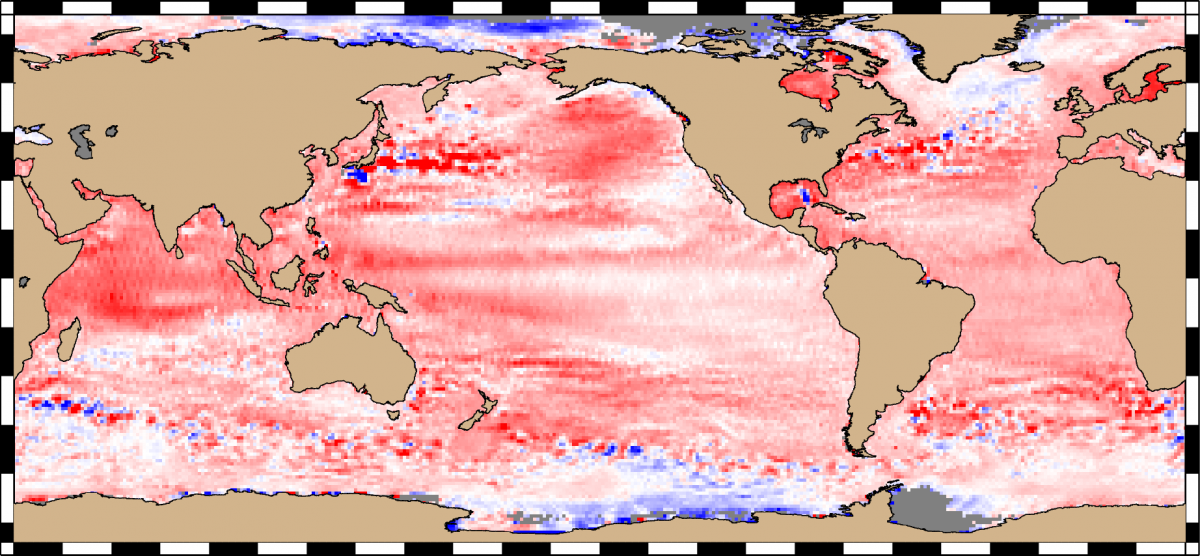
- Mean Sea Level Anomalies for 2020 from Jason-3 and SARAL/Altika:
- Inputs: 2020 NetCDF data from Jason-3 and SARAL/Altika
- Command: rads2grd
- Options: --ymd=20200101,20210101 -Sj3 -Ssa -omsla_2020.nc
where:
--ymd: year-month-day option for the time start/stop of 20200101 and 20210101.
-S: satellite identifiers (j3 => Jason-3, sa => SARAL/Altika)
-o: output NetCDF file named msla_2020.nc - Example: rads2grd --ymd=20200101,20210101 -Sj3 -Ssa -omsla_2020.nc
- Output: NetCDF file 'msla_2020.nc' rendered to +/-0.20 m
Manuals
Two manuals have been prepared by Remko Scharroo:
- RADS User Manual: The user manual describes step-by-step installation and configuration details, command-line tool/utilities usage/syntax, and the RADS library (a Fortran90 module providing the main functionalities for the RADS4 software).
- RADS Data Manual: The data manual describes the details of variables used in the RADS database.