Search Panel
CoastWatch User Stories (no longer updated)
| Title | Summary | Date Posted | Data Application |
|---|---|---|---|
TurtleWatch: A Tool for Reducing Loggerhead Turtle Bycatch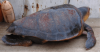
Feb 15, 2019 |
Fisheries bycatch has been implicated as a contributing factor in the population decline of endangered Pacific loggerhead turtles. In order to reduce interactions between longline fishing vessels based in Hawaii and loggerhead sea turtles, the NOAA Pacific Islands Fisheries Science Center created an experimental information product called TurtleWatch. | Fisheries & Aquaculture | |
Juvenile Salmon Shark Habitat Use Research
Feb 15, 2019 |
Standings of small juvenile salmon sharks have been reported between British Columbia, Canada and northern Baja California. A recent study used CoastWatch sea surface temperature data from the west coast regional node to explore the link between salmon shark strandings and water temperature. | Ecosystem Monitoring | |
Harmful Algal Bloom Monitoring and Forecasting in the Gulf of America
Feb 15, 2019 |
NOAA's National Ocean Service uses CoastWatch ocean color data along with cell counts and other environmental information to produce a Harmful Algal Blooms Observing System (HABSOS) and a Harmful Algal Bloom Operational Forecast System (HAB-OFS). | Ecosystem Monitoring , Water Quality | |
Identifying Climate-Driven Shifts in Jumbo Flying Squid Fishing Grounds
Feb 15, 2019 |
The jumbo flying squid (Dosidicus gigas), also known as the Humbolt squid, is an economically important fisheries species in the Eastern Pacific, currently accounting for approximately one third of the world's squid landings. Sea surface temperature and sea surface height data from NOAA OceanWatch Central Pacific node was used to research movements of their fishing ground. | Fisheries & Aquaculture | |
EcoCast: A tool to help fishers minimize bycatch off the US West Coast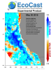
Feb 15, 2019 |
The EcoCast tool uses habitat suitability models and satellite-derived environmental data to predict where broadbill swordfish and three bycatch species (leatherback turtle, blue shark and California sea lion) are likely to be each day. Daily EcoCast maps help fishers identify fishing spots minimize fisheries bycatch and maximize fisheries target catch. | Fisheries & Aquaculture | |
Tropical Cyclone Heat Potential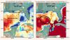
Mar 20, 2019 |
NOAA's Atlantic Oceanography & Meteorological Laboratory produces a Tropical Cyclone Heat Potential (TCHP) product represents a robust measure of how much energy is available in the ocean to sustain or modify the intensity of tropical cyclones.The NOAA CoastWatch Geo-Polar Blended surface sea temperature product and sea surface height data are used to produce global daily TCHP fields. | Climate & Weather | |
Ice Breaking Operations and Shipping in the Great Lakes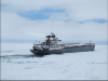
Mar 20, 2019 |
In order to understand ice formation and the types of ice in the Great Lakes, the NOAA Great Lakes Environmental Research Laboratory (GLERL) and the U.S. Coast Guard use Synthetic Aperture Radar (SAR) data from the NOAA CoastWatch Great Lakes Node to monitor six different types of ice, ice thickness, and ice cover. | Transportation & Safety | |
Great Lakes Quarterly Climate Impacts and Outlook
Mar 20, 2019 |
U.S. and Canadian Great Lakes agencies work together to document significant quarterly events, seasonal and yearly changes for the Great Lakes region and compile them into quarterly reports. NOAA Great Lakes CoastWatch data used in these bulletins includes Sea Surface Temperature, Synthetic Aperture Radar and real time marine data from buoys, coastal met stations, airports, and ships. | Climate & Weather , Ocean & Coastal Dynamics | |
Temperature Climate Indicators of Estuaries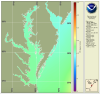
Jul 11, 2019 |
The National Estuary Program identifies, protects, and conserves water quality for ecologically significant estuaries and surrounding watersheds. The National Estuary Program uses Sea Surface Temperature time series products produced by the NOAA CoastWatch East Coast Node for estuary management. | Climate & Weather , Ecosystem Monitoring , Water Quality | |
NOAA researchers review approaches to satellite-derived coastal water quality products![Scientific Figure showing contributions of phytoplankton(link is external), CDOM, and nonalgal particulate(link is external) absorption coefficients(link is external) to total non-water absorption for waters with relatively (a) higher and (b) lower degrees of correlation between [Chl-a] and Rrs(490)/Rrs(555)](sites/default/files/styles/thumbnail/public/2022-12/1-s2.0-S0079661116302592-gr13a358.jpg?itok=QIc2gStc)
Oct 16, 2019 |
In a paper published in 2017 in Progress in Oceanography, coauthors Guanming Zheng and Paul M. DiGiacomo reviewed approaches to deriving water quality products from satellite ocean color data. They quantify and discuss the inherent uncertainties surrounding the characterization of water quality parameters of interest in coastal waters | Water Quality | |
Booklet: Advanced techniques for monitoring water quality using Earth Observation
Oct 19, 2019 |
AquaWatch, the Group on Earth Observations (GEO) Water Quality Initiative, presents information about water quality issues and monitoring in a variety of habitats and exemplars of water quality monitoring using archived and next generation Earth Observation data using technologies developed and exploited by researchers within the AquaWatch community. | Water Quality | |
The Tongue of the Ocean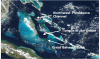
Sep 23, 2021 |
The Tongue of the Ocean is a deep water basin in the Bahamas that is surrounded to the east, west and south by a carbonate bank known as the Great Bahama Bank. The deep blue water of the Tongue is a stark contrast to the shallow turquoise waters of the surrounding Bank. | Climate & Weather , Ocean & Coastal Dynamics | |
A Satellite's View of Coastal Erosion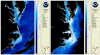
Sep 23, 2021 |
One expected impact of climate change is an increase in the frequency and severity of storms in the eastern United States. As such, many coastal communities and ecosystems are increasingly vulnerable to the detrimental impacts of coastal erosion. The CoastWatch East Coast node monitors coastal erosion by tracking in-water sediment values. | Climate & Weather , Ecosystem Monitoring , Ocean & Coastal Dynamics | |
Detecting Sea Level Anomalies with Satellites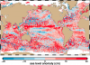
Sep 23, 2021 |
By studying sea level anomalies, scientists can improve understanding of ocean circulation patterns and improve forecasts of climatological events such as El Niño and La Niña. The NOAA Laboratory for Satellite Altimetry produces daily near-real time global sea level anomaly datasets from a constellation of radar altimeter missions. | Climate & Weather , Ecosystem Monitoring , Fisheries & Aquaculture , Ocean & Coastal Dynamics | |
Improving Satellite Sea Surface Temperature Analysis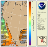
Sep 23, 2021 |
Information about sea surface temperature is important for weather and ocean forecasting, climate monitoring, military and defense operations, ecosystem assessment, fisheries analyses and tourism operations. NOAA's Sea Surface Temperature Team is working to improve their products by reanalyzing past data with NOAA's Advanced Clear-Sky Processor for Oceans (ACSPO) using the enterprise algorithm. | Climate & Weather , Ecosystem Monitoring , Fisheries & Aquaculture | |
Colors and Confusion: Making Better Color Choices for Data Visualization
Sep 23, 2021 |
Communication of scientific information and data to the public is part of NOAA’s mission, and scientific visualization is often the public’s first encounter with the agency’s data. This post gives an overview of recent advances and considerations for selecting and improving color selection for remote sensing data. NOAA CoastWatch will be experimenting with different colors for its data presentations. | Climate & Weather , Ecosystem Monitoring , Ocean & Coastal Dynamics , Transportation & Safety | |
Saharan Dust and its Impacts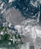
Sep 23, 2021 |
Winds blowing across the Sahara Desert send large clouds of dust that travel thousands of miles to the Atlantic Ocean or Mediterranean Sea. The growth of phytoplankton, microscopic plants at the base of the ocean food chain, is restricted by iron availability. When Saharan dust is blown into the ocean, phytoplankton use the iron and nutrients from the dust and begin to grow and reproduce. | Ecosystem Monitoring , Fisheries & Aquaculture | |
Monitoring Sea Surface Winds and Sea Ice with Satellite Radar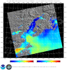
Sep 23, 2021 |
Synthetic Aperture Radar (SAR) is an active radar satellite instrument that transmits microwave pulses that bounce off the Earth’s surface. The radar signals are then processed into imagery that can be used to derive several geographic and non-geographic features including: wind speeds, oil spills, sea ice and ship detection. | Climate & Weather , Ocean & Coastal Dynamics , Transportation & Safety | |
Ocean acidification in the Caribbean
Sep 23, 2021 |
In collaboration with the NOAA Atlantic Oceanographic and Meteorological Laboratory's Ocean Chemistry and Ecosystems Division and NOAA Coral Reef Watch, the Caribbean/Gulf of America node of CoastWatch produces an ocean acidification product suite for the greater Caribbean region to track changes in the surface ocean that can be used as an important tool in coral reef research and management. | Climate & Weather , Ecosystem Monitoring , Fisheries & Aquaculture , Water Quality | |
Gulf of America Loop Current
Sep 23, 2021 |
The Gulf of America loop current brings warm Caribbean water northward between the Yucatan Peninsula and Cuba and into the Gulf. The current loops around the Gulf, flows southeastward into the Florida Strait where it serves as a parent to the Florida current and ultimately joins the Gulf Stream. | Climate & Weather , Ocean & Coastal Dynamics | |
Predicting Lake Ice Drifts in Cleveland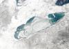
Mar 23, 2022 |
Meteorologists at the Cleveland Weather Forecast Office tell a story exemplifying how CoastWatch data supports their mission, and how accurate predictions can save lives. | Climate & Weather , Ecosystem Monitoring , Transportation & Safety | |
Predicting Winter Weather in Michigan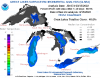
Mar 23, 2022 |
Forecasters at the Grand Rapids Weather Forecast Office describe how they use CoastWatch data to predict lake effect snow, freezing spray, and more. | Climate & Weather , Ecosystem Monitoring , Transportation & Safety | |
| CoastWatch Tools and Data Featured in Undergraduate Courses May 26, 2022 |
Dr. Sherry Palacios from CSUMB utilizes CoastWatch ERDDAP, Data Portal, and training materials in her oceanography curricula. | Climate & Weather , Ecosystem Monitoring , Ocean & Coastal Dynamics , Transportation & Safety , Water Quality | |
Predicting Vibrio Risk Using Satellite Data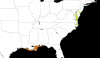
Jul 22, 2022 |
As sea temperatures rise, lethal Vibrio bacteria species populations are growing. The NOAA CoastWatch Caribbean and Gulf of America regional node at AOML has developed a model to predict Vibrio habitat suitability on a global scale. | Ecosystem Monitoring , Transportation & Safety | |
| Atlantic OceanWatch Assisting FEMA as Sargassum Reaches Record Levels in Caribbean Aug 8, 2022 |
Node Managers Dr. Goni and Dr. Trinanes are participating in the USVI/Sargassum Emergency FEMA Workshop in St. Croix | Ecosystem Monitoring , Ocean & Coastal Dynamics , Transportation & Safety , Water Quality | |
C-HARM: Predicting Harmful Algal Blooms with Satellite Data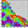
Mar 14, 2023 |
The West Coast Node (WCN) of CoastWatch is home to thousands of datasets; from ACSPO SST to Vector Winds, their ERDDAP server stores decades of historic climate data. But one group of products stands out with its impact on the coastal communities of California and Southern Oregon: C-HARM. |
Ecosystem Monitoring , Fisheries & Aquaculture , Transportation & Safety , Water Quality | |
Sargassum FAQ
Apr 4, 2023 |
A Frequently Asked Questions (FAQs) for Sargassum was composed by the NOAA Atlantic Oceanographic & Meteorological Laboratory (AOML) in partnership with NOAA CoastWatch Caribbean, Gulf of America, and Atlantic OceanWatch Node. | Ecosystem Monitoring , Transportation & Safety , Water Quality | |
Monitoring water clarity on Cape Cod with satellite imagery: CoastWatch-led study 
May 7, 2024 |
CoastWatch researchers recently collaborated with scientists in Massachusetts to study the feasibility of using satellite data to monitor water clarity in Cape Cod. | Ecosystem Monitoring , Water Quality |