| Date |
March 23, 2022
|
|---|---|
| Content Type |
User Story
|
|
|
| Data Applications |
Climate & Weather
Ecosystem Monitoring
Transportation & Safety
|
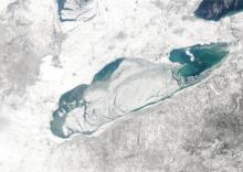
In February 2021, warming temperatures led the Cleveland Weather Forecast Office to suspect two phenomena: people would venture onto the Lake Erie ice, and that ice would move. Meteorologists turned to MODIS (Moderate Resolution Imaging Spectroradiometer) imagery and Sea Surface Temperature data provided by CoastWatch to study their Great Lake. They were able to confirm that ice in the middle of the lake was shifting northward, which would likely cause the fast ice along the Cleveland shores to break away. Knowing their citizens’ proclivity towards recreational excursions atop the lake ice, the National Weather Service issued warnings through marine weather statements and social media posts advising against walking on the ice.
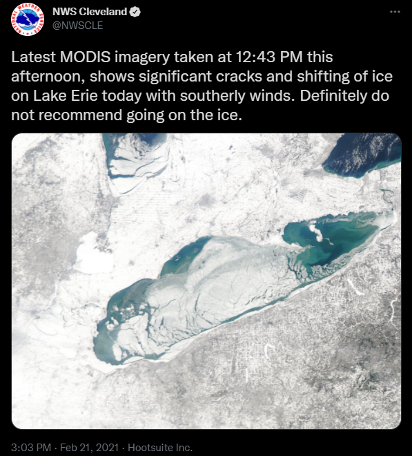
When that fast ice did drift from the shore, 10 people needed to be rescued -- uninjured -- from the floes. Because the meteorologists chose to use satellite data provided by CoastWatch, threats were correctly predicted and damage was prevented that day.
This is not the only time the NWS WFO in Cleveland has looked to CoastWatch for information. MODIS imagery and SST data contribute to the Great Lakes Ice Forecasts, as well as year-round predictions. From Marine Program Leader, Kirk Lombardy:
“CoastWatch has become an integral part of our operations not only during the ice season but during the rest of the shipping and recreational boating season. Our partnership with the Great Lakes Environmental Research Laboratory (GLERL), as a CoastWatch node, also has benefited us greatly with the data they provide for the Great Lakes. I would say that the partnership allowed GLERL to rapidly increase the data output from their agency to benefit the users in the National Weather Service across the Great Lakes region.