| Date |
September 23, 2021
|
|---|---|
| Content Type |
User Story
|
|
|
| Data Applications |
Climate & Weather
Ecosystem Monitoring
Fisheries & Aquaculture
Ocean & Coastal Dynamics
|
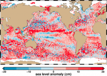
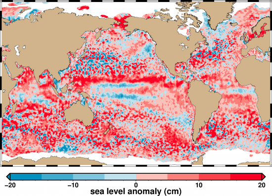
The sea surface is a dynamic mixture of bumps and dips resulting from a variety of factors including gravity, ocean currents and the rotation of the Earth. Scientists study variations in sea surface height using radar altimeters on satellites. These altimeters emit radar pulses that bounce off the ocean’s surface and are detected by a sensor on the satellite when they return. Sea surface height derived from satellite altimeters is accurate to within about 3-4 centimeters.
Anomalies in sea level can be identified by calculating the difference between the measured sea surface height and the average sea surface height. By studying sea level anomalies, scientists can improve understanding of ocean circulation patterns and improve forecasts of climatological events such as El Niño and La Niña.
The NOAA Laboratory for Satellite Altimetry produces daily near-real time global sea level anomaly datasets from a constellation of radar altimeter missions. These datasets are now available through CoastWatch/OceanWatch and can be accessed here.
References and Related Reading
- CryoSat Ground Segment, Instrument Processing Facility L1B, Products Specification Format, ESA: CS-RS-ACS-GS-5106, Issue: 6.4, April 2015. https://earth.esa.int/documents/10174/125273/CryoSat_L1_Products_Format_Specification(link is external)
- CryoSat Product Handbook, April 2012. https://earth.esa.int/documents/10174/125272/CryoSat_Product_Handbook(link is external)
- Jason-3 Product Handbook, SALP-MU-M-OP-16118-CN, edition 1.2. Feb. 2016. https://www.nodc.noaa.gov/media/pdf/jason2/j3_user_handbook.pdf
- Leuliette, E. W., and R. Scharroo (2010). Integrating Jason-2 into a Multiple-Altimeter Climate Data Record. Marine Geodesy, 33(1), 504517. doi:10.1080/01490419.2010.487795
- OSTM/Jason-2 Products Handbook, CNES: SALP-MU-M-OP-15815-CN EUMETSAT: EUM/OPS-JAS/MAN/08/0041 JPL: OSTM-29-1237: NOAA/NESDIS: Polar Series/OSTM J400, Issue: 1 rev 10, October, 2016, https://www.nodc.noaa.gov/media/pdf/jason2/j2_user_handbook.pdf
- SARAL/AltiKa Products handbook, SALP-MU-M-OP-15984-CN, edition 2.5. July 2016. http://www.aviso.altimetry.fr/fileadmin/documents/data/tools/SARAL_Altika_products_handbook_01.pdf(link is external)
- Scharroo, R., E. Leuliette, M. Naeije, C. Martin-Puig, and N. Pires (2016), RADS Version 4: An Efficient Way to Analyse the Multi-Mission Altimeter Database, Living Planet Symposium, Proceedings of the conference held 9-13 May 2016 in Prague, Czech Republic. Edited by L. Ouwehand. ESA-SP Volume 740, ISBN: 978-92- 9221-305- 3.
- Sentinel-3 User Handbook, ESA: GMES-S3OP-EOPG-TN-13-0001, Issue 1, September 2013. https://sentinel.esa.int/documents/247904/685236/Sentinel-3_User_Handbook