| Date |
March 20, 2019
|
|---|---|
| Content Type |
User Story
|
|
|
| Data Applications |
Climate & Weather
|
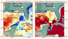
Tropical Cyclones (known as Hurricanes in the Atlantic and eastern Pacific Ocean basins and as Typhoons in the western Pacific basin) are some of the most destructive weather events on the planet. The path of these storms and their intensity are the two main outputs of the forecast models, as they provide vital information for saving lives and determining possible economic and environmental impacts. In addition to the appropriate atmospheric conditions, the heat stored in the upper layers of the ocean plays an important role in tropical cyclone formation and intensification. Tropical cyclones require ocean temperatures above 26℃ for development. AOML’s Tropical Cyclone Heat Potential (TCHP) quantifies the upper ocean heat content from the ocean surface to the 26℃ isotherm depth, and it represents a robust measure of how much energy is available in the ocean to sustain or modify the intensity of a tropical cyclone. High values of TCHP have been associated with the sudden intensification of a number of tropical cyclones (see references). Fields of TCHP are created daily and serve to identify regions where the ocean conditions are appropriate for tropical cyclone intensity changes.
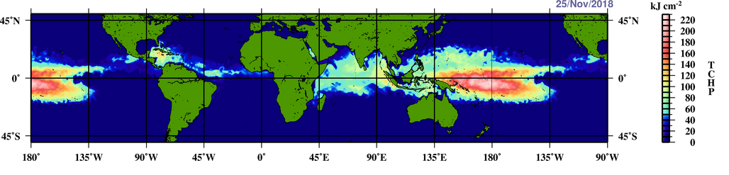
The NOAA CoastWatch Geo-Polar Blended surface sea temperature product and NOAA CoastWatch sea surface height data are routinely used to determine the surface temperature and the depth of the warm water layer for global daily TCHP fields.

While tracking Hurricane Michael, NOAA used TCHP to predict its intensification based on various potential paths. Similarly, TCHP was also used to determine the magnitude of storm surge on specific areas.
Hurricane Michael did not enter into the high TCHP waters in the Loop Current where the potential to intensify further, under the appropriate atmospheric conditions, is greatest.
References and Related Readings
Goni, G., Demaria, M., Knaff, J., Sampson, C., Ginis, I., Bringas, F., Mavume, A., Lauer, C., Lin, I., Ali, M., Sandery, P., Ramos-Buarque, S., Kang, K., Mehra, A., Chassignet, E., Halliwell, G. (2009). Applications of Satellite-Derived Ocean Measurements to Tropical Cyclone Intensity Forecasting. Oceanography, 22(3), 190-197.
Lin, I., Goni, G. J., Knaff, J. A., Forbes, C., & Ali, M. M. (2012). Ocean heat content for tropical cyclone intensity forecasting and its impact on storm surge. Natural Hazards, 66(3), 1481-1500.