| Date |
June 27, 2022
|
|---|---|
| Content Type |
Announcement
|
|
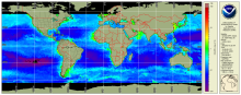
Multi-sensor 9 km ocean color products are now available on the data portal and ERDDAP. These global gap-free data come from 3 instruments: the VIIRS sensor aboard both SNPP and NOAA-20, plus the OLCI on Sentinel 3A. The OLCI Level-1B data are from EUMETSAT, and VIIRS Level-1B data are provided by NOAA, JPSS. The NOAA/STAR Ocean Color Team then produce the chlorophyll, light attenuation (downwelling) at 490 nm (Kd490), and Suspended Particulate Material (SPM) analysis products on a ~10 day delay.
More information and data access on our webpage.
Acronyms used:
ERDDAP - Environmental Research Division's Data Access Program
EUMETSAT - European Organisation for the Exploitation of Meteorological Satellites
NOAA - National Oceanic and Atmospheric Administration
OLCI - Ocean and Land Colour Instrument
SNPP - Suomi National Polar-orbiting Partnership
SPM - Suspended Particulate Matter
STAR - Center for Satellite Applications and Research
VIIRS - Visible Infrared Imaging Radiometer Suite