Ocean Color Level 2 (EDR) is produced through NOAA Multi-Sensor Level 1 to Level 2 processing system (MSL12) from IDPS satellite data record (SDR, Level 1b). Level 3 mapped and composite products are also available, now including a 2-sensor (VIIRS: SNPP plus NOAA-20) merged daily chlorophyll and diffuse attenuation coefficients (Kd(490) and Kd(PAR) .
Data Access
Product Overview
Ocean Color satellite sensors measure visible light at specific wavelengths which leaves the surface of the ocean and arrives at the top of the atmosphere where the sensor is located. From these visible spectral measurements, along with simultaneous measurements in the near infrared (NIR) and the short wave infrared (SWIR) wavelengths, the color of the ocean, or normalized water leaving radiances (nLw), can be calculated. Then, the nLws are used to derive other ocean properties such as the concentration of chlorophyll-a (chlor-a or sometimes chl, which is the green pigment responsible for photosynthesis and therefore an indicator of the amount of phytoplankton biomass in the ocean water) and the coefficient of extinction for downwelling irradiance (Kd(PAR) and Kd(490) which are related to water clarity).
The ocean color datasets described here are from the Visible and Infrared Imaging Radiometer Suite (VIIRS) sensor aboard the Suomi-NPP satellite (SNPP) which was launched in November 2011 and NOAA-20 launched in November 2017. Global life-of-mission science quality data are available beginning on 2 January 2012 for SNPP. NOAA ocean color data are processed using NOAA Multi-Sensor Level 1 to Level 2 processing system (MSL12) developed by the NOAA/STAR Ocean Color Team. See documentation tab for relevant publications describing the system and algorithms.
The VIIRS near real time products and the science quality collection differ in several ways (Table 1). Generally, the near real time data are best suited for applications where timeliness of reasonable quality data is most important whereas science quality data are best suited for applications where consistent, best available quality are required and a ~2 week delay is acceptable.
The 2-sensor merged daily 4 km global products are derived from MSL12 v1.3 for both SNPP plus NOAA-20. Note that sole sensor SNPP products are processed from MSL12 v1.2 and sole sensor NOAA-20 products are processed from MSL12 v 1.3. The upgrade to MSL12 v1.3 for SNPP is planned (along with a mission-long reprocessing for science quality).
| Parameter | Near real-time | Science Quality |
|---|---|---|
| Latency | ~12 hours (best effort) | Delayed 15 days |
| Sensor Data Record (SDR) | IDPS Operational SDR | NOAA/STAR Ocean Color improved SDR |
| Ancillary Data | Predicted | Assimilated |
| Spatial Coverage | May have gaps | Complete |
Standard VIIRS ocean color data Level 2 products (both near real time and science quality) include:
- Normalized water-leaving (nLw) radiance at five visible bands (nominal center wavelengths)
- M1 (410nm)
- M2 (443nm)
- M3 (486nm)
- M4 (551nm)
- I1 (638 nm)
- M5 (671nm)
- Chlorophyll-a concentration
- Diffuse attenuation coefficient at 490 nm (Kd490), and Diffuse attenuation coefficient of photosynthetically active radiation (KdPAR)
- QA score (an empirical product quality assessment )
See Table 2 for quick reference matrix of additional near real time VIIRS ocean color products. The Ocean Color Granule Selector and the new CoastWatch Data Portal are online tools to interactively preview, choose and download L2 granule files. Data files are in NetCDF4/CF but differ from past NOAA CoastWatch products in their use of hierarchical groups to store attributes, variables, and dimensions. The CoastWatch Utilities Software has been updated to work with these files. Additional metadata can be obtained using THREDDS services such as ISO or OPeNDAP.
| Product Description | Processing Level | Nominal Spatial Resolution | Chl-a | nLws | KdPAR | Kd490 | Rrs (672) | Chlorophyll Fronts | True Color |
|---|---|---|---|---|---|---|---|---|---|
| Daily granule global swath | L2 | 750 m | X | X | X | X | X | X | |
| Daily merged mapped CW regions* | L3 | 750 m | X | X | X | X | X | ||
| Daily merged global single file | L3 | 4 km | X | X | X | X | |||
| Daily 2-sensor merged global single file | L3 | 4 km | X | X | |||||
| Daily merged global sectorized** | L3 | 750 m | X | X | X | X | X (3 sectors: UY, VY, WY) | ||
| 7-day merged global single file | L3 | 4 km | X | X | X | X | |||
| 7-day merged global sectorized** | L3 | 750 m | X | X | X | X | |||
| True monthly merged global single file | L3 | 4 km | X | X | X | X | |||
| True monthly merged global sectorized** | L3 | 750 m | X | X | X | X | |||
| 61 day merged for CW regions* | L3 | 750 m | X | X | |||||
| Anomaly for CW regions* | L3 | 750 m | X | X | |||||
| Daily granule Mediterranean | L1b, L2 | 750 m | X | X | X | X | |||
| Daily merged mapped Mediterranean | L3 | 750 m | X | X | X | ||||
| Daily merged mapped Australia | L3 | 750 m | X | X | X |
*See Figure 1 for locations of CoastWatch regions
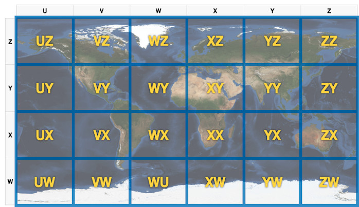
**See Figure 2 for description and identification of sectors.
***Under development for April 2019 release.
Figure 1. Seven heritage CoastWatch "CONUS" regions (clockwise from top right: Great Lakes, NorthEast, SouthEast, Caribbean, Gulf of America, Hawaii, West Coast).
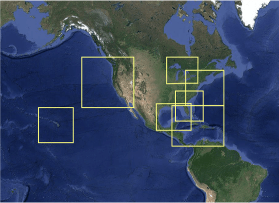
Figure 2. Twenty-four sectors identified for file naming convention. Sectors enable downloads of select subset regions from global high resolution VIIRS ocean color science quality data.
Product Details
| Short Names |
VIIRS_OC_NRT_L2
VIIRS_OC_NRT_L3
|
|---|---|
| Product Families |
Ocean Color
|
| Measurements |
Chlorophyll-a Concentration
Diffuse Attenuation Coefficients
Normalized Water-Leaving Radiances
Ocean Color Quality Score
|
| Processing Levels |
Level 2
Level 3
|
| Latency Groups |
0 Hours <= 24 Hours (NRT)
|
| Latency Details |
~12-24 h |
| Spatial Resolution Groups |
100m < 2km
2km+
|
| Spatial Resolution Details |
750m @ Nadir; ~1.7km at swath edge (granules) and 4 km |
| Data Providers |
NOAA
NESDIS
STAR
|
Spatial Coverage
Global
| Description |
180W - 180E |
|---|
CoastWatch US Regions
| Description |
Also known as the CoastWatch Regional Nodes: OceanWatch Central Pacific, PolarWatch, Great Lakes, East Coast, Atlantic OceanWatch - Caribbean - Gulf of America, WaterWatch (inland rivers), West Coast |
|---|
Processing Algorithms
MSL12
| Description |
Multi-Sensor Level-1 to Level-2 (MSL12) Ocean Color Data Processing System |
|---|
Platforms
Documentation
Algorithm Theoretical Basis Document (ATBD): Wang, M., X. Liu, L. Jiang and S. Son, "The VIIRS Ocean Color Products", Algorithm Theoretical Basis Document Version 1.0, 68 pp., June 2017.
- Jiang, L. and M. Wang, 2013, "Identification of pixels with stray light and cloud shadow contaminations in the satellite ocean color data processing", Appl. Opt., 52, 6757-6770 (2013). doi:10.1364/AO.52.006757
- Jiang, L. and M. Wang, 2014, "Improved near-infrared ocean reflectance correction algorithm for satellite ocean color data processing", Opt. Express, 22, 21657-21678 (2014). doi:10.1364/OE.22.021657
- Mikelsons, K., M. Wang, L. Jiang, and M. Bouali, 2014, "Destriping algorithm for improved satellite-derived ocean color product imagery", Opt . Express, 22, 28058-28070 (2014). doi:10.1364/OE.22.028058
- Son, S. and M. Wang, 2015, "Diffuse attenuation coefficient of the photosynthetically available radiation Kd(PAR) for global open ocean and coastal waters", Remote Sens. Environ., 159, 250-258 (2015). doi:10.1016/j.rse.2014.12.011
- Sun, J. and M. Wang, 2014, "Visible Infrared Imaging Radiometer Suite solar diffuser calibration and its challenges using solar diffuser stability monitor", Appl. Opt ., 53, 8571-8584 (2014). doi:10.1364/AO.53.008571
- Sun, J. and M. Wang, 2015, "On-orbit calibration of Visible Infrared Imaging Radiometer Suite reflective solar bands and its challenges using a solar diffuser", Appl. Opt ., 54, 7210-7223 (2015). doi:10.1364/AO.54.007210
- Sun, J. and M. Wang, 2015, "On-orbit characterization of the VIIRS solar diffuser and solar diffuser screen", Appl. Opt ., 54, 236-252 (2015). doi:10.1364/AO.54.000236
- Sun, J. and M. Wang, 2015, "Radiometric calibration of the Visible Infrared Imaging Radiometer Suite reflective solar bands with robust characterizations and hybrid calibration coefficients", Appl. Opt ., 54, 9331-9342 (2015). doi:10.1364/AO.54.009331
- Sun, J. and M. Wang, 2016, "VIIRS reflective solar bands calibration progress and its impact on ocean color products", Remote Sens., 8, 194 (2016). doi:10.3390/rs8030194
- Sun, J., M. Chu, and M. Wang, 2016, "Degradation nonuniformity in the solar diffuser bidirectional reflectance distribution function", Appl. Opt ., 55, 6001-6016 (2016). doi:10.1364/AO.55.006001
- Sun, J., M. Wang, L. Tan, and L. Jiang, 2014, "An efficient approach for VIIRS RDR to SDR data processing", IEEE Geosci . Remote Sens. Lett ., 11, 2037-2041 (2014). doi:10.1109/LGRS.2014.2317553
- Sun, J., X. Xiong, E. Waluschka, and M. Wang, 2016, "Suomi National Polar- Orbitting Partnership Visible Infrared Imaging Radiometer Suite polarization sensitivity analysis", Appl. Opt., 55, 7645-7658 (2016). doi:10.1364/AO.55.007645
- Wang, M. and S. Son, 2016, "VIIRS -derived chlorophyll-a using the ocean color index method", Remote Sens. Environ ., 182, 141-149 (2016). doi:10.1016/j.rse.2016.05.001
- Wang, M., 2016, "Rayleigh radiance computations for satellite remote sensing: accounting for the effect of sensor spectral response function", Opt. Express, 24, 12414-12429 (2016). doi:10.1364/OE.24.012414
- Wang, M., P. Naik, and S. Son, 2016, "Out-of-band effects of satellite ocean color sensors", Appl. Opt ., 55, 2312-2323 (2016). doi:10.1364/AO.55.002312
- Wang, M., W. Shi, L. Jiang, and K. Voss, 2016, "NIR- and SWIR-based on-orbit vicarious calibrations for satellite ocean color sensors", Opt. Express, 24, 20437-20453 (2016). doi:10.1364/OE.24.020437
- Wang, M., W. Shi, L. Jiang, X. Liu, S. Son, and K. Voss, 2015, "Technique for monitoring performance of VIIRS reflective solar bands for ocean color data processing", Opt. Express, 23, 14446-14460 (2015). doi:10.1364/OE.23.014446
- Wang, M., X. Liu, L. Tan, L. Jiang, S. Son, W. Shi, K. Rausch, and K. Voss, 2013, "Impacts of VIIRS SDR performance on ocean color products", J. Geophys . Res. Atmos., 118, 10347-10360 (2013). doi:10.1002/jgrd.50793
- Xiong, X., J. Sun, J. Fulbright, Z. Wang, and J. Butler, 2015, "Lunar calibration and performance for S-NPP VIIRS reflective solar bands", IEEE Trans. Geosci . Remote Sens., 54, 1052-1061 (2015). doi:10.1109/TGRS.2015.2473665
- Algorithm Theoretical Basis Document (ATBD) for VIIRS Ocean Color is currently in progress.
Related Algorithm Theoretical Basis Document (ATBD)
- Wang, M. and X. Liu, "MODIS Ocean Color Products Using the SWIR Method", MODIS-SWIR Algorithm Theoretical Basis Document, 40 pp., NOAA Product System Development and Implementation (PSDI), February 2012.