VIIRS Science Quality Ocean Color Level 2 (EDR) is produced by NOAA/STAR Ocean Color Team through NOAA Multi-Sensor Level 1 to Level 2 processing system (MSL12) using an improved calibration for the satellite data record (OC-SDR, which is Level 1b). CoastWatch Level-3 composites, binned and mapped data products also available.
Data Access
Product Overview
The current VIIRS SNPP science quality collection, released in CoastWatch as of 07 August 2017, is produced from MSL12 v1.2* using OC-SDR v04. VIIRS NOAA-20 Science Quality is currently in development. NOAA-20 Near real-time is already available.
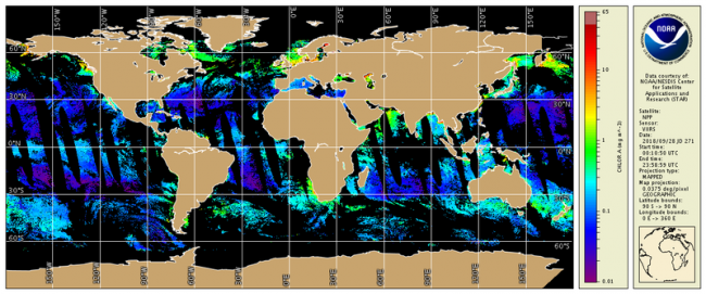
Ocean Color satellite sensors measure visible light at specific wavelengths which leaves the surface of the ocean and arrives at the top of the atmosphere where the sensor is located. nLw, can be calculated. nLws are used to derive other ocean properties such as the concentration of chlorophyll-a (chlor-a, chlora, or sometimes chl , which is the green pigment responsible for photosynthesis and therefore and indicator of the amount of phytoplankton biomass in the ocean water) and the coefficients for attenuation of downwelling irradiance (Kd(PAR) and Kd(490) which are related to water clarity).
The ocean color datasets described here are from the Visible Infrared Imaging Radiometer Suite (VIIRS) sensor aboard the Suomi-NPP satellite (SNPP) which was launched in November 2011 and aboard the NOAA-20 which was launched in November 2017. The ocean color science quality collection differ in several ways from the near real-time products (Table 1).
*Note that the metadata in the NetCDF files show v1.20 from the beginning of the collection (2 Jan. 2012) up tthrough 24 April 2017 and v1.21 from 25 April 2017 forward. This version change did not affect retrieval values for the standard products served by CoastWatch.
Table 1. Comparison of primary processing differences for VIIRS SNPP near real time versus science quality ocean color data.
| Parameter | Near real-time | Science Quality |
|---|---|---|
| Latency | ~12 hours (best effort) | Delayed 15 days |
| Sensor Data Record (SDR) | IDPS Operational SDR | SDR produced by the NOAA/STAR ocean color team |
| Ancillary Data | Predicted | Assimilated |
| Spatial Coverage | May have gaps | As complete as possible |
Standard VIIRS SNPP ocean color data Level 2 products from MSL12 v1.2(both near real-time and science quality) include:
- Normalized water-leaving (nLw) radiance at 6 visible bands (nominal center wavelengths)
- M1 (410nm)
- M2 (443nm)
- M3 (486nm)
- M4 (551nm)
- M5 (671nm)
- I1 (638 nm)
- Chlorophyll-a concentration
- Diffuse attenuation coefficient at 490 nm (Kd(490)), and
- Diffuse attenuation coefficient of photosynthetically active radiation (Kd(PAR))
- QA Score (a quantitative assessment of VIIRS ocean color performance with respect to an empirical catalog of in situ spectra, Wei et al., 2016; see reference tab)
See Table 2 for quick reference matrix of additional science quality VIIRS ocean color products. The Ocean Color Granule Selector is a tool to interactively preview, choose and download L2 granule files. Data files are in NetCDF4/CF but differ from past NOAA CoastWatch products in their use of hierarchical groups to store attributes, variables, and dimensions. CoastWatch Utilities Software has been updated to work with these files. Additional metadata can be obtained using THREDDS services such as ISO or OPeNDAP.
Table 2. Quick reference matrix of science quality VIIRS ocean color products available from CoastWatch.
| Product Description | Processing Level | Nominal Spatial Resolution | Chl-a | nLws | Kd(PAR) | Kd(490) | QA Score |
|---|---|---|---|---|---|---|---|
| Daily granule @750 m | L2 | 750 m | X | X | X | X | X |
| Daily merged global sectorized * | L3 | 750 m | X | X | X | X | not currently available |
| 7-day merged global sectorized * | L3 | 750 m | X | X | X | X | not currently available |
| True monthly merged global sectorized * | L3 | 750 m | X | X | X | X | not currently available |
| Daily merged global single file | L3 | 4 km | X | X | X | X | X |
| 7-day merged global single file | L3 | 4 km | X | X | X | X | X |
| Monthly merged global single file | L3 | 4 km | X | X | X | X | X |
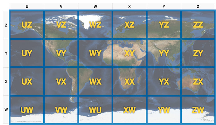
*See Figure 1 for description and identification of sectors.
Level-2 science quality ocean color products are organized by Year and Day-of-the-Year. Filenames will appear as follows: V2017187003435_NPP_SCINIR_L2.nc where:
| V: | Sensor VIIRS |
| 2017: | Year of observation (YYYY) |
| 187: | Day of year for the observation (DDD) |
| 003435: | Hour, minutes, and seconds of the start of observation (hhmmss) in UTC |
| NPP: | Spacecraft S-NPP |
| SCINIR: | Sensor data record source and environmental data record algorithm. Indicates the standard Science Quality output for distribution |
| L2: | Processing level. L2 includes calibrated and geolocated geophysical products |
Figure 1. Twenty-four sectors identified for file naming convention. Sectors enable downloads of select subset regions from global high resolution VIIRS ocean color science quality data.
Product Details
| Temporal Start Date |
January 2, 2011
|
|---|---|
| Temporal Coverage |
SNPP: 02 January 2011 through 15 days before present (15 day delay on Science Quality) |
| Product Families |
Ocean Color
|
| Measurements |
Chlorophyll-a Concentration
Diffuse Attenuation Coefficients
Normalized Water-Leaving Radiances
Ocean Color Quality Score
|
| Processing Levels |
Level 2
Level 3
|
| Latency Groups |
0 Hours <= 24 Hours (NRT)
|
| Latency Details |
~12-24 h |
| Spatial Resolution Groups |
100m < 2km
2km+
|
| Spatial Resolution Details |
750 m @ Nadir; ~1.7 km at swath edge full resolution in L2 granules |
| Data Providers |
NOAA
NESDIS
STAR
|
Spatial Coverage
Global
| Description |
180W - 180E |
|---|
CoastWatch Global Sectors
| Description |
The 24 sectors identified for file naming convention when referring to VIIRS data. |
|---|---|
| Image |
|
Processing Algorithms
MSL12
| Description |
Multi-Sensor Level-1 to Level-2 (MSL12) Ocean Color Data Processing System |
|---|
Platforms
Documentation
Algorithm Theoretical Basis Document (ATBD): Wang, M., X. Liu, L. Jiang and S. Son, "The VIIRS Ocean Color Products", Algorithm Theoretical Basis Document Version 1.0, 68 pp., June 2017.
- Sun, J., X. Xiong, E. Waluschka, and M. Wang, 2016, "Suomi National Polar- Orbiting Partnership Visible Infrared Imaging Radiometer Suite polarization sensitivity analysis", Appl. Opt., 55, 7645-7658 (2016). doi:10.1364/AO.55.007645
- Wang, M. and S. Son, 2016, "VIIRS -derived chlorophyll-a using the ocean color index method", Remote Sens. Environ ., 182, 141-149 (2016). doi:10.1016/j.rse.2016.05.001
- Sun, J. and M. Wang, 2016, "VIIRS reflective solar bands calibration progress and its impact on ocean color products", Remote Sens., 8, 194 (2016). doi:10.3390/rs8030194
- Sun, J., M. Chu, and M. Wang, 2016, "Degradation nonuniformity in the solar diffuser bidiretional reflectance distribution function", Appl. Opt ., 55, 6001-6016 (2016). doi:10.1364/AO.55.006001
- Wang, M., 2016, "Rayleigh radiance computations for satellite remote sensing: accounting for the effect of sensor spectral response function", Opt. Express, 24, 12414-12429 (2016). doi:10.1364/OE.24.012414
- Wang, M., P. Naik, and S. Son, 2016, "Out-of-band effects of satellite ocean color sensors", Appl. Opt ., 55, 2312-2323 (2016). doi:10.1364/AO.55.002312
- Wang, M., W. Shi, L. Jiang, and K. Voss, 2016, "NIR- and SWIR-based on-orbit vicarious calibrations for satellite ocean color sensors", Opt. Express, 24, 20437-20453 (2016). doi:10.1364/OE.24.020437
- Sun, J. and M. Wang, 2015, "On-orbit calibration of Visible Infrared Imaging Radiometer Suite reflective solar bands and its challenges using a solar diffuser", Appl. Opt ., 54, 7210-7223 (2015). doi:10.1364/AO.54.007210
- Sun, J. and M. Wang, 2015, "On-orbit characterization of the VIIRS solar diffuser and solar diffuser screen", Appl. Opt ., 54, 236-252 (2015). doi:10.1364/AO.54.000236
- Sun, J. and M. Wang, 2015, "Radiometric calibration of the Visible Infrared Imaging Radiometer Suite reflective solar bands with robust characterizations and hybrid calibration coefficients", Appl. Opt ., 54, 9331-9342 (2015). doi:10.1364/AO.54.009331
- Son, S. and M. Wang, 2015, "Diffuse attenuation coefficient of the photosynthetically available radiation Kd(PAR) for global open ocean and coastal waters", Remote Sens. Environ., 159, 250-258 (2015). doi:10.1016/j.rse.2014.12.011
- Wang, M., W. Shi, L. Jiang, X. Liu, S. Son, and K. Voss, 2015, "Technique for monitoring performance of VIIRS reflective solar bands for ocean color data processing", Opt. Express, 23, 14446-14460 (2015). doi:10.1364/OE.23.014446
- Xiong, X., J. Sun, J. Fulbright, Z. Wang, and J. Butler, 2015, "Lunar calibration and performance for S-NPP VIIRS reflective solar bands", IEEE Trans. Geosci . Remote Sens., 54, 1052-1061 (2015). doi:10.1109/TGRS.2015.2473665
- Sun, J. and M. Wang, 2014, "Visible Infrared Imaging Radiometer Suite solar diffuser calibration and its challenges using solar diffuser stability monitor", Appl. Opt ., 53, 8571-8584 (2014). doi:10.1364/AO.53.008571
- Mikelsons, K., M. Wang, L. Jiang, and M. Bouali, 2014, "Destriping algorithm for improved satellite-derived ocean color product imagery", Opt . Express, 22, 28058-28070 (2014). doi:10.1364/OE.22.028058
- Sun, J., M. Wang, L. Tan, and L. Jiang, 2014, "An efficient approach for VIIRS RDR to SDR data processing", IEEE Geosci . Remote Sens. Lett ., 11, 2037-2041 (2014). doi:10.1109/LGRS.2014.2317553
- Jiang, L. and M. Wang, 2014, "Improved near-infrared ocean reflectance correction algorithm for satellite ocean color data processing", Opt. Express, 22, 21657-21678 (2014). doi:10.1364/OE.22.021657
- Jiang, L. and M. Wang, 2013, "Identification of pixels with stray light and cloud shadow contaminations in the satellite ocean color data processing", Appl. Opt., 52, 6757-6770 (2013). doi:10.1364/AO.52.006757
- Wang, M., X. Liu, L. Tan, L. Jiang, S. Son, W. Shi, K. Rausch, and K. Voss, 2013, "Impacts of VIIRS SDR performance on ocean color products", J. Geophys . Res. Atmos., 118, 10347-10360 (2013). doi:10.1002/jgrd.50793