The NOAA Laboratory for Satellite Altimetry's (LSA) sea surface height team produces 0.25-degree longitude/latitude Level-3 sea level anomaly (SLA) daily datasets by applying optimal interpolation to along-track satellite observations over the global ocean from a constellation of radar altimeter missions. Theses grids are produced with near-real time (3-5 hour latency) data. Geostrophic Currents are produced from the SLA and are included in the dataset.
Data Access
Product Overview
The NOAA Laboratory for Satellite Altimetry (LSA) sea surface height team produces 0.25-degree longitude/latitude Level-3 sea level anomaly (SLA) daily datasets by applying optimal interpolation to along-track satellite observations over the global ocean from a constellation of radar altimeter missions. Geostrophic currents are derived from the SLA and are included in the dataset. Theses grids are produced with near-real time (NRT; 3-5 hour latency) data and a delayed-time (DT), improved accuracy, product is available for the time period 2012 to 2018.
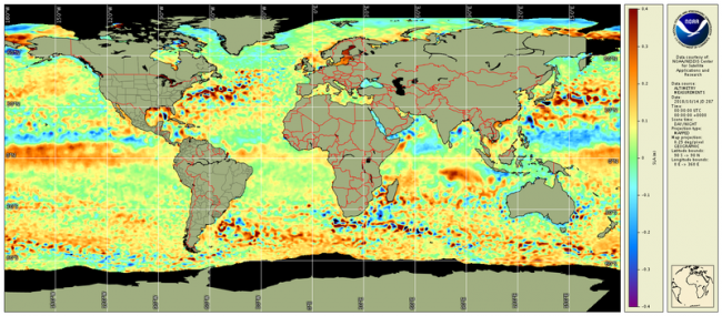
Sea Level Anomaly Product (pictured above)The NOAA/NESDIS Laboratory for Satellite Altimetry provides near-real time (NRT) and delayed-time (DT) gridded Level-3 sea level anomaly (SLA) products. The data are produced by applying optimal interpolation to along-track satellite observations from a constellation of radar altimeter missions. The along-track altimetry data for each of the missions are from the Radar Altimetry Database System (RADS). This product is a global ocean product with a spatial resolution of 0.25-degree longitude/latitude. The near-real time gridded SLA product is available from February 2017 through the present. Currently, Jason-3, AltiKa, Cryosat-2, Sentinel-3A, and Sentinel-3B data are used in the processing of the NRT dataset. Jason-2 was included through 1 October 2019. The NRT dataset is also part of NOAA’s OceanWatch Monitor. The delayed time SLA data are available for years 2012-2018. The DT data are of different quality than the NRT gridded SLA data. For each day, along-track data from all available missions are used and only final Geophysical Data Records (GDR)/Non-Time Critical (NTC) data are used in the processing of the DT dataset, making this product to be more accurate.
Geostrophic Currents ProductThe NOAA/NESDIS Laboratory for Satellite Altimetry provides near-real time and delayed-time, zonal and meridional components of the geostrophic current. The currents are produced using the NOAA/NESDIS Laboratory for Satellite Altimetry's daily sea level anomaly grids and the conventional f-plane geostrophic current equations. At the equator, the beta-plane approximation is used. This product is a global ocean product with a spatial resolution of 0.25-degree longitude/latitude. The near-real time geostrophic currents are available from March 2019 through the present. The delayed time geostrophic currents are available for years 2012-2018. The geostrophic currents are variables within the NRT and DT SLA data files.
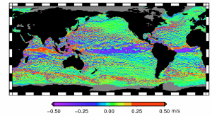
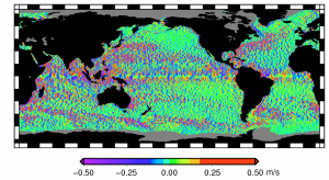
Figure: NOAA LSA NRT Gridded Geostrophic Currents in m s-1 for 9 May 2019. Left is zonal component (ugos), right is meridional component (vgos). Black is land. Gray is ice or missing data.
NOTE: Jason-2 will permanently cease acquisition of scientific data at 06:48 UTC on 1 October 2019 due to aging-related issues onboard the spacecraft.
- The gridded multi-mission, Sea level Anomaly and Geostrophic Currents Near-real time products will continue to include Jason-2 until October 11.
- When produced, the gridded multi-mission, Sea level Anomaly and Geostrophic Currents delayed-mode products will include Jason-2 up to October 11.
The Radar Altimeter Database System (RADS) is an effort of the Department of Earth Observation and Space Systems (DEOS) at TU Delft and the NOAA Laboratory for Satellite Altimetry to establish a harmonized, validated, and cross-calibrated sea level data base from satellite altimeter.
Product Details
| Short Names |
RADS-NRT-SLA-Daily-L4
|
|---|---|
| Temporal Start Date |
January 1, 2017
|
| Product Families |
Ocean Currents
Sea Surface Height
|
| Measurements |
Geostrophic Currents
Sea Surface Height
|
| Processing Levels |
Level 4
|
| Latency Groups |
0 Hours <= 24 Hours (NRT)
|
| Latency Details |
12 hours |
| Spatial Resolution Groups |
2km+
|
| Spatial Resolution Details |
0.25° |
| Data Providers |
ESA
EUMETSAT
NOAA
NESDIS
STAR
LSA
|
Spatial Coverage
Global
| Description |
180W - 180E |
|---|
Processing Algorithms
RADS
| Description |
Radar Altimeter Database System (RADS) |
|---|---|
| Algorithm Details |
The Radar Altimeter Database System (RADS) is employed is employed at NESDIS/STAR as a enterprise multi-mission algorithm providing consistent sea level anomaly, waves, and ocean surface wind speed products. RADS is a joint effort of the NOAA Laboratory for Satellite Altimetry (LSA), EUMETSAT, and Department of Earth Observation and Space Systems (DEOS) at the Delft University of Technology to establish a harmonized, validated, and cross-calibrated sea level data base from satellite altimeter data. RADS was designed primarily as a database tool for expert altimetry users but through NOAA CoastWatch and LSA training materials, may have appeal at both expert and entry levels: advisory councils, water management authorities, teachers, and students. RADS homogenizes data from multiple missions which in turn are used to generate Level-2P products for operational users, including data assimilation at NOAA and the US Navy (e.g. the Global Real-Time Ocean Forecast System (Global RTOFS) and the West Coast Operational Forecast System) and Level-2P and Level-3 products distributed through NOAA CoastWatch (Sea Level Anomaly and along-track altimetry). It is also used as calibration/validation platform. The database is a collection of continually updated NetCDF datasets. Geophysical Data Records and associated corrections are processed and stored in homogenized NetCDF pass files. Near real-time processing is done two times per day at NOAA for the following missions: Jason-3, Sentinel-3A, Sentinel-3B, AltiKa/SARAL, and CryoSat-2. Reprocessing is done jointly with EUMETSAT. These files can then be used to generate products using the RADS data utilities. Variables used within RADS include (not all inclusive):
|
| Documentation |
Scharroo, R., E. W. Leuliette, J. L. Lillibridge, D. Byrne, M. C. Naeije, and G. T. Mitchum, RADS: Consistent multi-mission products, in Proc. of the Symposium on 20 Years of Progress in Radar Altimetry, Venice, 20-28 September 2012, European Space Agency Special Publication, ESA SP-710, p. 4 pp., 2013. RADS Data Manual The data manual describes the details of variables used in the RADS database. |
Platforms
JASON-2
| Description |
Reference altimetry mission |
|---|---|
| Platform Type |
Low Earth Orbit Satellite (LEO)
|
| Instruments | |
| Organizations |
CNES
EUMETSAT
NASA
NOAA
|
| Orbital Altitude |
1309.5 km
|
| Orbital Inclination |
66°
|
| Equatorial Crossing Times |
Variable
|
JASON-3
| Description |
Altimetry reference mission |
|---|---|
| Platform Type |
Low Earth Orbit Satellite (LEO)
|
| Instruments | |
| Organizations |
CNES
EUMETSAT
NASA
NOAA
|
| Orbital Altitude |
1336 km
|
| Orbital Period |
112.4 minutes
|
| Orbital Inclination |
66°
|
| Equatorial Crossing Times |
Variable
|
Sentinel-6
| Description |
Sentinel-6 |
|---|---|
| Platform Type |
Low Earth Orbit Satellite (LEO)
|
| Instruments | |
| Organizations |
CNES
EC
ESA
EUMETSAT
NASA
NOAA
|
| Orbital Altitude |
1336 km
|
| Orbital Inclination |
66 °
|
| Equatorial Crossing Times |
Variable
|
Instruments
Poseidon-3
| Description |
Poseidon 3 |
|---|---|
| Platforms | |
| Instrument Types |
Radar Altimeter
|
| Organizations |
CNES
|
Poseidon-3B
| Description |
Poseidon-3B |
|---|---|
| Platforms | |
| Instrument Types |
Radar Altimeter
|
| Organizations |
CNES
|
SRAL
| Description |
Synthetic aperture Radar Altimeter |
|---|---|
| Platforms | |
| Instrument Types |
Radar Altimeter
|
| Organizations |
ESA
|
Documentation
- CryoSat Ground Segment, Instrument Processing Facility L1B, Products Specification Format, ESA: CS-RS-ACS-GS-5106, Issue: 6.4, April 2015. https://earth.esa.int/documents/10174/125273/CryoSat_L1_Products_Format_Specification
- CryoSat Product Handbook, April 2012, https://earth.esa.int/documents/10174/125272/CryoSat_Product_Handbook
- Jason-3 Product Handbook, SALP-MU-M-OP-16118-CN, edition 1.2, Feb. 2016 https://www.nodc.noaa.gov/media/pdf/jason2/j3_user_handbook.pdf
- Leuliette, E. W., and R. Scharroo (2010). Integrating Jason-2 into a Multiple-Altimeter Climate Data Record. Marine Geodesy, 33(1), 504–517. doi:10.1080/01490419.2010.487795
- OSTM/Jason-2 Products Handbook, CNES: SALP-MU-M-OP-15815-CN EUMETSAT : EUM/OPS-JAS/MAN/08/0041 JPL : OSTM-29-1237 : NOAA/NESDIS : Polar Series/OSTM J400, Issue: 1 rev 10, October, 2016, https://www.nodc.noaa.gov/media/pdf/jason2/j2_user_handbook.pdf
- SARAL/AltiKa Products handbook, SALP-MU-M-OP-15984-CN, edition 2.5, July 2016; http://www.aviso.altimetry.fr/fileadmin/documents/data/tools/SARAL_Altika_products_handbook_01.pdf
- Scharroo, R., E. Leuliette, M. Naeije, C. Martin-Puig, and N. Pires (2016), RADS Version 4: An Efficient Way to Analyse the Multi-Mission Altimeter Database, Living Planet Symposium, Proceedings of the conference held 9-13 May 2016 in Prague, Czech Republic. Edited by L. Ouwehand. ESA-SP Volume 740, ISBN: 978-92- 9221-305- 3.
- Sentinel-3 User Handbook, ESA: GMES-S3OP-EOPG-TN-13-0001, Issue 1, September 2013, https://sentinel.esa.int/documents/247904/685236/Sentinel-3_User_Handbook
Citation
LSA data are distributed at no cost to the users to promote scientific utilization of the data with the stipulation that the users of the data agree to follow the policy described below:
- LSA data are produced on a best effort basis.
- In publications, presentations, or on web pages based on LSA data the following acknowledgment should be included.
"Altimetry data are provided by the NOAA Laboratory for Satellite Altimetry."