CoastWatch/OceanWatch produces 0.25-degree longitude/latitude Level-3 gridded sea-surface salinity (SSS) daily mean dataset by box averaging Soil Moisture Active Passive (SMAP) satellite observations over the global ocean.
Data Access
Product Overview
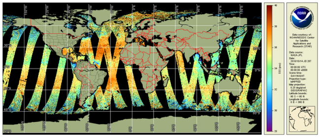
CoastWatch/OceanWatch produces 0.25-degree longitude/latitude Level-3 gridded sea-surface salinity (SSS) daily mean dataset by box averaging Soil Moisture Active Passive (SMAP) satellite observations over the global ocean. Daily files are available back to the beginning of 2015.
CoastWatch/OceanWatch Level-3 SSS products are generated directly from the NASA Jet Propulsion Laboratory (JPL) SMAP Level-2B SSS near real time swath HDF5 files. These products improve the application of satellite SSS products in NOAA by minimizing the data latency to within 24 hours of Level-2 data availability.
Product Details
| Short Names |
SMAP SSS
|
|---|---|
| Temporal Start Date |
April 1, 2015
|
| Product Families |
Sea Surface Salinity
|
| Measurements |
Sea Surface Salinity
Sea Surface Wind Speed
|
| Processing Levels |
Level 3
|
| Latency Groups |
0 Hours <= 24 Hours (NRT)
|
| Latency Details |
Less than 24 hours |
| Spatial Resolution Groups |
2km+
|
| Spatial Resolution Details |
30 km nominal sensor resolution CoastWatch Level-3 product is gridded to 0.25º (~25 km) |
| Data Providers |
NASA
JPL
|
Spatial Coverage
Global
| Description |
180W - 180E |
|---|