VIIRS Sea Ice Concentration, Sea Ice Thickness and Ice Surface Temperature NOAA CoastWatch/OceanWatch/PolarWatch Level 3, Daily and daily 4-day rolling merged, mapped composites in both polar stereographic projections and CW sector mapped for Northern and Southern hemispheres.
Data Access
Product Overview
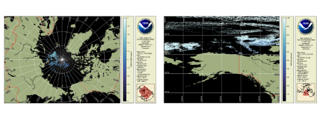
VIIRS Sea Ice Concentration, Sea Ice Thickness and Ice Surface Temperature, NOAA CoastWatch/OceanWatch/PolarWatch Level 3, Daily and daily 4-day rolling merge, mapped composites are nominally at native spatial resolution (~750 m), clear sky only.
- North Polar (NP06) and South Polar (SP06) are Polar Stereographic projected daily composites
- Six Northern hemisphere and six Southern hemisphere high latitude CoastWatch VIIRS sectors (see sector map below)
- North Sectors: UZ, VZ, WZ, XZ, YZ, ZZ
- South Sectors: UW, VW, WU, XW, YW, ZW
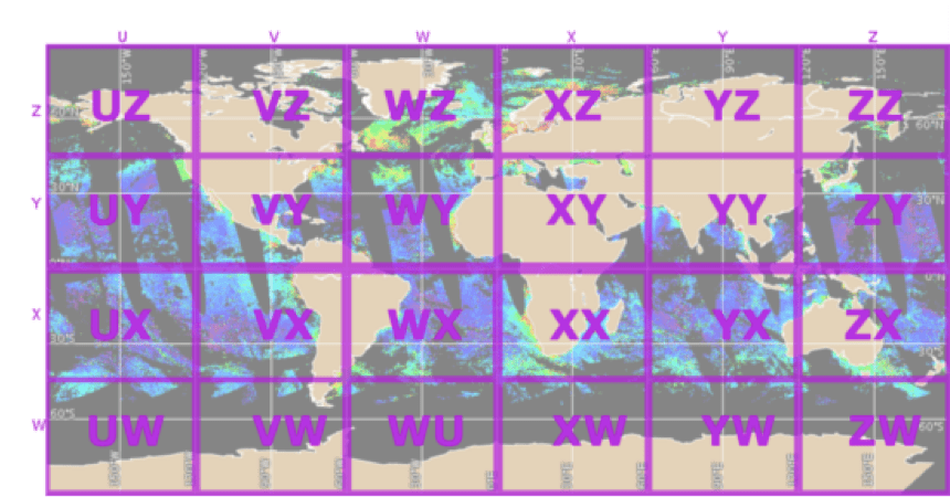
Map of CoastWatch regional sectors
Data Provider: JPSS Center for Satellite Applications and Research Cryosphere Team
STAR Cryosphere Environmental Data Record Team Lead: Jeff Key
Sea ice age is defined as the time that has passed since the formation of the surface layer of an ice covered region of the ocean.
Sea ice concentration is the fraction of a horizontal cell covered by ice.
NDE Enterprise Ice Age/Thickness Algorithm
One-dimensional Thermodynamic Ice Model (OTIM):
- Based on the surface energy budget at thermo-equilibrium state
- Independent of historical records for ice thickness and age estimation
- Capable of retrieving daytime and nighttime sea and lake ice thickness under both clear and cloudy sky conditions
IDPS Sea Ice Concentration is an intermediate product (IP)
- Algorithm computes ice fractions based on ice and water tie points determined from VIIRS I1 (0.64 µm) and I2 (0.865 µm) reflectance and surface temperature from the VIIRS Surface Temperature IP
Enterprise Sea Ice Concentration Algorithm
- Use threshold tests to detect possible ice cover: Daytime and Nighttime
- Use a tie-point algorithm to derive reflectance (temperature) for pure ice pixel, and then calculate ice concentration
Product Details
| Temporal Coverage |
Daily and |
|---|---|
| Product Families |
Polar Sea Ice
|
| Measurements |
Sea Ice Concentration
Sea Ice Temperature
Sea Ice Thickness
Visible And Near IR Radiometry
|
| Processing Levels |
Level 3
|
| Latency Groups |
0 Hours <= 24 Hours (NRT)
|
| Latency Details |
about 12 to 24 h |
| Spatial Resolution Groups |
100m < 2km
|
| Spatial Resolution Details |
Nominal 750 m |
| Data Providers |
NOAA
NESDIS
OSPO
STAR
CoastWatch
Cryosphere Team
|
Spatial Coverage
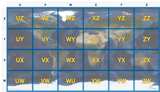
CoastWatch Global Sectors
| Description |
The 24 sectors identified for file naming convention when referring to VIIRS data. |
|---|---|
| Image |
|
Polar (Artic/Antarctic)
| Description |
60N - 90N 60S - 90S |
|---|
Platforms
Documentation
Wang, Xuanji and Key, Jeffrey R., NOAA/NESDIS Center for Satellite Applications and Research, Algorithm Theoretical Basis Document: ABI and VIIRS Ice Thickness and Age, Version 1.0, 17 December 2015.
- Ice Age ATBD (NDE), (PDF, 2.6 MB)
Liu, Yinghui and Key, Jeffrey R.,, NOAA/NESDIS Center for Satellite Applications and Research, Algorithm Theoretical Basis Document: Ice Surface Temperature, Ice Concentration, and Ice Cover, Version 1.0, 17 December 2015.
- Ice Cover ATBD (NDE), (PDF, 1.69 MB)
EDR Long Term-Monitoring
- Data Viewer at STAR: VIIRS Sea Ice; AMSR-2/ GCOM-W1 Sea Ice
- University of Wisconsin Cryo Team CIMSS website