GOES-East

Description

Geostationary Operational Environmental Satellite - East

Platform Type
Geostationary Earth Orbit Satellite (GEO)
Instruments
Organizations
NASA
NOAA
Orbital Longitude
75.2° W
Orbital Altitude
35786 km

Oceanic Heat Content, Mixed Layer Depth and Depths of 20°C and 26°C Isotherms

Product Families
Ocean Heat Content
Summary

Oceanic Heat Content (OHC) is the measure of the integrated vertical temperature from the sea surface to the depth of the 26°C isotherm and computed from the altimeter-derived isotherm depths in the upper ocean relative to 20°C.  Global 0.25 degree grids are generated daily for OHC, mixed layer depth and depths of 20°C and 26°C isotherms for 3 ocean basins:  North Atlantic, North Pacific and South Pacific 

NOAA Geo-Polar Blended Global Sea Surface Temperature Analysis (Level 4)

Product Families
Sea Surface Temperature
Summary

The NOAA geo-polar blended SST is a daily 0.05° (~5km) global high resolution satellite-based sea surface temperature (SST) Level-4 analyses generated on an operational basis. This analysis combines SST data from US, Japanese and European geostationary infrared imagers, and low-earth orbiting infrared (U.S. and European) SST data, into a single high-resolution 5-km product.  The three flavors of blended SST products are night only; day/night, and diurnal warming. 

ACSPO Global SST from ABI

Product Families
Sea Surface Temperature
Summary

The ABI SST data are produced from GOES-East (GOES-16) and GOES-West (at present GOES-18, before 2023/01/10 GOES-17) satellite using the NOAA Advanced Clear-Sky Processor for Ocean (ACSPO) v2.xx enterprise system. Currently, near-real time (NRT) data are produced at STAR, with a ~2-6 hour latency. A Reanalysis (RAN) dataset for GOES-16 is also available. The data are available in NetCDF4 format, compliant with the GHRSST Data Specifications v2 (GDS2). Currently, the data are archived on PO.DAAC and available at this Coast Watch page as a 2week rotated buffer.
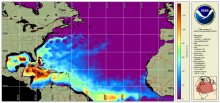
Seascape Pelagic Habitat Classification

Product Families
Seascape Classification
Summary

MBON Seascapes identifies spatially explicit water masses with particular biogeochemical features using a model and satellite-derived measurements.  The seascape product is generated as monthly and 8-day composites at 5 km spatial resolution