OLCI Sentinel-3A and 3B regional coverage (US coasts of interest, a.k.a. "CONUS" but including Hawaii) Level-3 mapped daily composites of ocean color remote sensing reflectances (Rrs(λ), chlorophyll-a concentration and derived water quality related products including diffuse attenuation coefficient at 490 nm (Kd490), normalized fluorescence line height (NLFH), and total suspended matter (TSM) from the EUMETSAT processing.
Data Access
Product Overview
The Sentinels are a suite of satellite missions developed to serve the operational needs of the European Copernicus program for Earth observations. NOAA CoastWatch/OceanWatch provides Sentinel data to US users through official arrangements with ESA, EUMETSAT and the European Commission.
Sentinel-3 is a multi-instrument mission to measure sea- and land-surface temperature, ocean and land color and sea-surface topography. Sentinel-3A was launched on 16 February 2016. Sentinel 3B launched on 25 April 2018 with the same suite of instruments.
The Ocean and Land Colour Instrument (OLCI) is based on heritage from Envisat’s Medium Resolution Imaging Spectrometer (MERIS) to measure visible and thermal infrared radiances with which to generate true color, ocean color radiances and derived products such as chlorophyll, total suspended matter (TSM), diffuse attenuation coefficient at 490 nm (Kd(490)), absorption at 443 nm (a(443), and normalized fluorescence line height (nflh). OLCI has 21 bands at wavelengths from 400 nm to 1020 nm (400, 412, 442, 490, 510, 560, 620, 665, 674, 681, 709, 754, 779, 865, 885, 1024 nm), a spatial resolution of ~300 m (at nadir) and a swath width of 1270 km.
CoastWatch distributes EUMETSAT native products (L2) also generates and serves mapped and composited products (L3) for US Coastal regions ("CONUS") and global sectors. Global sectors are "hi-res" 300 m 216 sectors (AA through RL, Figure 1) and "VIIRS-res" 750 m 24 sectors which match VIIRS ocean color (Figure 2). See the data access tab for product listings and links.
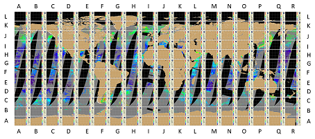
Figure 1. CoastWatch hi-res OLCI Sentinel-3 sector coordinate map
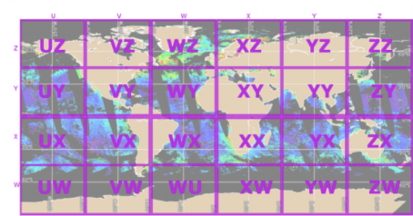
Figure 2. CoastWatch VIIRS-res sector coordinate map
See the ESA Sentinel-3 website for more information: http://www.esa.int/Our_Activities/Observing_the_Earth/Copernicus/Sentinel-3/Introducing_Sentinel-3
OLCI Level 1b (e.g., true color) and ocean color Level 2 data (e.g., radiances, chlorophyll, etc.) are generated by EUMETSAT (https://www.eumetsat.int/sentinel-3) and served by CoastWatch
See the EUMETSAT ocean data product pages for more information and links to specific documents: https://www.eumetsat.int/sentinel-3
Product Details
| Product Families |
Ocean Color
|
|---|---|
| Measurements |
Chlorophyll-a Concentration
Diffuse Attenuation Coefficients
Normalized Fluorescence Line Height
Remote Sensing Reflectance
Suspended Particulate Matter
|
| Processing Levels |
Level 3
|
| Latency Groups |
0 Hours <= 24 Hours (NRT)
|
| Latency Details |
8 hours |
| Spatial Resolution Groups |
100m < 2km
|
| Spatial Resolution Details |
300 m |
| Data Providers |
EUMETSAT
NOAA
NESDIS
STAR
CoastWatch
|
Spatial Coverage
CoastWatch US Regions
| Description |
Also known as the CoastWatch Regional Nodes: OceanWatch Central Pacific, PolarWatch, Great Lakes, East Coast, Atlantic OceanWatch - Caribbean - Gulf of America, WaterWatch (inland rivers), West Coast |
|---|
Processing Algorithms
OC4Me
| Description |
ESA's 4-band combination chlorophyll-a algorithm (OC4ME) |
|---|
Platforms
Instruments
OLCI
| Description |
Ocean and Land Colour Instrument |
|---|---|
| Platforms | |
| Instrument Types |
Imager
|
| Organizations |
ESA
|