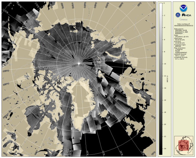
The daily composite of Synthetic Aperture Radar (SAR) Normalized Radar Cross Section (NRCS) imagery covering the Arctic and sub-Arctic maritime regions over a period of one day are available at 1-km resolution. These high-resolution, weather- and time-agnostic measurements of surface backscatter contain detailed information tailored for sea ice classification purposes.
Data Access
Product Overview
The daily composite of Synthetic Aperture Radar (SAR) Normalized Radar Cross Section (NRCS) imagery covering the Arctic and sub-Arctic maritime regions over a period of one day are available at 1-km resolution. These high-resolution, weather- and time-agnostic measurements of surface backscatter contain detailed information tailored for sea ice classification purposes.
A composite for typical day contains around 200-400 individual scenes gathered from several C-Band SAR systems, including Sentinel-1A/B, RADARSAT-2, and RADARSAT Constellation Mission, which are calibrated with values given by the SAR data provider and are then projected and resampled onto a 1km polar stereographic grid. The files are produced in SAROPS (SAR Operational Product System) by the Water Surface Conditions/Sea Surface Roughness group within the NOAA STAR Satellite Oceanography and Climatology Division.
For further details on the individual granules that make these composites and for links to the GeoTIFF versions of these files, please see the SAR NRCS page.
Data Courtesy of the Copernicus Program, RADARSAT Constellation Mission, and the Canadian Space Agency.
Product Details
| Short Names |
NRCS Composites
|
|---|---|
| Temporal Coverage |
00:00Z-23:59Z (daily) |
| Product Families |
Sea Surface Roughness
|
| Measurements |
Normalized Radar Cross-Section
|
| Processing Levels |
Level 2
Level 4
|
| Latency Groups |
24+ hours (Delayed)
|
| Latency Details |
Generated at 14Z the following day |
| Spatial Resolution Groups |
100m < 2km
|
| Spatial Resolution Details |
1km |
| Data Providers |
Copernicus
CSA
RCM
NOAA
STAR
|
Spatial Coverage
Arctic and Sub-Arctic Maritime
| Description |
>40°N |
|---|
Platforms
RadarSat-2
| Description |
RadarSat-2 |
|---|---|
| Platform Type |
Low Earth Orbit Satellite (LEO)
|
| Instruments | |
| Organizations |
CSA
|
| Orbital Altitude |
798 km
|
| Orbital Period |
100.7 minutes
|
| Orbital Inclination |
98.6°
|
| Equatorial Crossing Times |
06:00 desc
|
Sentinel-1
| Description |
Sentinel - 1A / 1B |
|---|---|
| Platform Type |
Low Earth Orbit Satellite (LEO)
|
| Instruments | |
| Organizations |
ESA
Copernicus
|
| Orbital Altitude |
693 km
|
| Orbital Period |
98.6 minutes
|
| Orbital Inclination |
98.18°
|
| Equatorial Crossing Times |
06:00 desc
|
Documentation
Synthetic Aperture Radar Marine Users Manual. Ed C.R Jackson and J.R. Apel: NOAA: Washington, DC, USA, 2004. ISBN 0-16-073214-X