SEVIRI

Description

Spinning Enhanced Visible and InfraRed Imager

Platforms
Instrument Types
Imager
Organizations
EUMETSAT

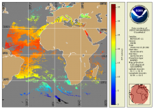
NOAA Geo-Polar Blended Global Sea Surface Temperature Analysis (Level 4)

Product Families
Sea Surface Temperature
Summary

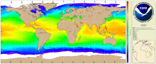
The NOAA geo-polar blended SST is a daily 0.05° (~5km) global high resolution satellite-based sea surface temperature (SST) Level-4 analyses generated on an operational basis. This analysis combines SST data from US, Japanese and European geostationary infrared imagers, and low-earth orbiting infrared (U.S. and European) SST data, into a single high-resolution 5-km product.  The three flavors of blended SST products are night only; day/night, and diurnal warming. 

Seviri (MSG) - Geostationary - Level 3

Product Families
Sea Surface Temperature
Summary

The National Oceanic and Atmospheric Administration's Office of Satellite Data Processing and Distribution are generating operational sea surface temperature (SST) retrievals from the Geostationary Operational Environmental Satellites GOES-East and West. The generation of SSTs began with GOES-8 in 2000 and has continued to be generated through GOES-15