The National Oceanic and Atmospheric Administration's Office of Satellite Data Processing and Distribution are generating operational sea surface temperature (SST) retrievals from the Geostationary Operational Environmental Satellites GOES-East and West. The generation of SSTs began with GOES-8 in 2000 and has continued to be generated through GOES-15
Data Access
| Data Tool Links | |
| Sample Filenames | 2016_298_34E.hdf |
| HTTPS |
Product Overview
The National Oceanic and Atmospheric Administration's Office of Satellite Data Processing and Distribution are generating operational sea surface temperature (SST) retrievals from the Geostationary Operational Environmental Satellites GOES-East and West. The generation of SSTs began with GOES-8 in 2000 and has continued to be generated through GOES-15. They are situated at longitude 135oW and 75oW, respectively, thus allowing the acquisition of high-temporal-resolution SST retrievals. The algorithm calculates SST by utilizing a fully physical retrieval scheme based on modified total least squares (MTLS, Koner et al., 2015) and a probabilistic (Bayesian) approach for cloud masking (Merchant et al., 2005). A more detailed description can be described in the Algorithms and Bayesian Cloud Mask section below.
The GOES-13 and 15 imagers observe both northern and southern hemisphere sectors every half an hour. These 5-band (0.6, 3.9, 6.7, 10.7, 13.3 µm) images are processed to retrieve SST retrievals at 4-km resolution. The 3.9, 10.7 & 13.3 µm channels are used to determine the SST, while the 0.6, 3.9 and 10.7 µm channels are used to detect cloud contamination. Individual sectors are output as GHRSST Level-2 P SST product files, and retrievals are also remapped, averaged and composited hourly into single-byte per pixel "flat" binary files and posted to a server for user access. The retrievals are available approximately 90 minutes after the nominal epoch of the SST determinations. 3-hour and 24-hour composite files are also made available. CoastWatch Regional Imagery is generated every three hours by combining the 1-hourly SST images for these areas.
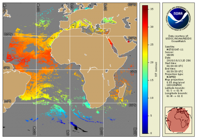
The same algorithm approach is used to generate SSTs from Meteosat-11 data (centered at 0¡ longitude), taking a sub-selection of channels from the SEVIRI instrument that corresponds with those of the GOES-Imager. The main differences for the end-user are that the Meteosat SST products are "full-disk", every 15 minutes, and have a resolution at the nadir point of ~3-km, at least for the GHRSST L2P data.
Algorithms
Prior to the implementation of the fully physical retrieval algorithm with GOES-13 and 15, the algorithm retrieval schemes were still based on Radiative Transfer Modeling (RTM), generating skin temperatures rather than bulk temperatures. The form of the prior GOES operational SST equation was:
Product Details
Near real-time + 3 days
Less than 24 hours
6 km
Documentation
- Koner, P. K., A. Harris, and E. Maturi. "A Physical Deterministic Inverse Method for Operational Satellite Remote Sensing: An Application for Sea Surface Temperature Retrievals." IEEE Transactions on Geoscience and Remote Sensing 53, no. 11 (November 2015): 5872-88. doi:10.1109/TGRS.2015.2424219.
- Kurihara, Yukio, Hiroshi Murakami, and Misako Kachi. "Sea Surface Temperature from the New Japanese Geostationary Meteorological Himawari-8 Satellite." Geophysical Research Letters 43, no. 3 (February 16, 2016): 2015GL067159. doi:10.1002/2015GL067159.
- Maturi, Eileen, Andy Harris, Jon Mittaz, Chris Merchant, Bob Potash, Wen Meng, and John Sapper. "NOAA's Sea Surface Temperature Products From Operational Geostationary Satellites." Bulletin of the American Meteorological Society 89, no. 12 (December 1, 2008): 1877-88. doi:10.1175/2008BAMS2528.1.
- Merchant, Christopher J., and Pierre Le Borgne. "Retrieval of Sea Surface Temperature from Space, Based on Modeling of Infrared Radiative Transfer: Capabilities and Limitations." Journal of Atmospheric and Oceanic Technology 21, no. 11 (November 1, 2004): 1734-46. doi:10.1175/JTECH1667.1.
- Merchant, C. J., A. R. Harris, E. Maturi, and S. Maccallum. "Probabilistic Physically Based Cloud Screening of Satellite Infrared Imagery for Operational Sea Surface Temperature Retrieval." Quarterly Journal of the Royal Meteorological Society 131, no. 611 (October 1, 2005): 2735-55. doi:10.1256/qj.05.15.
- Merchant, C. J., A. R. Harris, E. Maturi, O. Embury, S. N. MacCallum, J. Mittaz, and C. P. Old. "Sea Surface Temperature Estimation from the Geostationary Operational Environmental Satellite-12 (GOES-12)." Journal of Atmospheric and Oceanic Technology 26, no. 3 (March 1, 2009): 570-81. doi:10.1175/2008JTECHO596.1.
- Wick, Gary A., John J. Bates, and Donna J. Scott. "Satellite and Skin-Layer Effects on the Accuracy of Sea Surface Temperature Measurements from the GOES Satellites." Journal of Atmospheric and Oceanic Technology 19, no. 11 (November 1, 2002): 1834-48. doi:10.1175/1520-0426(2002)019<1834%3ASASLEO>2.0.CO%3B2 (2002).
- Wu, Xiangqian, W. Paul Menzel, and Gary S. Wade. "Estimation of Sea Surface Temperatures Using GOES-8/9Radiance Measurements." Bulletin of the American Meteorological Society 80, no. 6 (June 1999): 1127-38.