Sea Surface Height

Satellite altimeters use active radar to observe the surface height of the ocean which is not smooth or flat. Fluid hills and valleys deviate from a reference (mean geoid) height at the ocean surface. These vertical gradients are of interest for sea level rise, storm predictions, ocean currents, ecosystem ecology and other applications.

Sea level Anomaly and Geostrophic Currents, multi-mission, global, optimal interpolation, gridded

Product Families
Ocean Currents
Sea Surface Height
Summary

The NOAA Laboratory for Satellite Altimetry's (LSA) sea surface height team produces 0.25-degree longitude/latitude Level-3 sea level anomaly (SLA) daily datasets by applying optimal interpolation to along-track satellite observations over the global ocean from a constellation of radar altimeter missions. Theses grids are produced with near-real time (3-5 hour latency) data.  Geostrophic Currents are produced from the SLA and are included in the dataset.

Along-track significant wave height, wind speed and sea level anomaly from multiple altimeters

Product Families
Sea Surface Height
Sea Surface Winds
Summary

The NOAA Laboratory for Satellite Altimetry's (LSA) sea surface height team produces 0.25-degree longitude/latitude Level-3 significant wave height, wind speed, and sea level anomaly (SLA) daily datasets by applying optimal interpolation to along-track satellite observations over the global ocean from a constellation of radar altimeter missions. Theses grids are produced with near-real time (3-5 hour latency) data.

NOAA CoastWatch MA Monitor

Monitor Type
Data Assurance
Description

The NOAA CoastWatch MA Monitor provides the real-time delivery status of all Moderate Assurance (MA) products.

Near Real-Time Altimeter Validation System (NRTAVS)

Monitor Type
Quality Assurance
Description

NRTAVS produces comprehensive, running web-based summaries of individual correction terms, as well as wind, wave and sea-surface height for satellite radar altimeter missions.

OceanWatch Monitor

Monitor Type
Data Assurance
Quality Assurance
Description

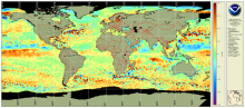
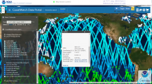
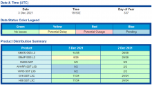
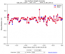
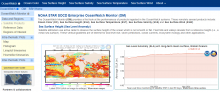
This OceanWatch Monitor provides an easy way for CoastWatch users to assess the state of the available products at one location (under one URL). The current capability includes monitoring of five different environmental data record (EDRs): Ocean Color (OC) Chlorophyll-a, Sea Surface Height (SSH), Sea Surface Salinity (SSS), Sea Surface Temperature (SST) and Sea Surface Wind (SSW) aka Ocean Surface Vector Wind. The OM framework is flexible to accommodate newer products for existing EDRs, and scalable for adding a newer EDR. Besides product monitoring within a given EDR family, it is envisioned to allow a joint analysis of different EDRs under an inter-thematic module. However, not all available CW products have been included in the monitor yet and this will be done incrementally. Likewise, the various data sets may have different latencies depending on their scientific needs.  See Quickstart Userguide for more information.

CoastWatch Data Quality & Availability Dashboard

Monitor Type
Data Assurance
Quality Assurance
Description

This Data Availability Dashboard gives a concise report of product availability and a quick look at a bulk time series to monitor for product stability

CDN Moderate Assurance Monitor

Monitor Type
Data Assurance
Description

The CDN Moderate Assurance Monitor displays a daily report for current and past availability of all Moderate Assurance (MA) products.