NOAA Advanced Clear-Sky Processor for Ocean (ACSPO) L3S-LEO SST is a family of multisensor gridded ("L3") 0.02º resolution super-collated ("S") products. The L3S-LEO family is organized into three lines: PM, AM and Daily. The AM and PM lines correspond to 9:30am/pm and 1:30am/pm equator crossing times, respectively. The Daily line combines PM and AM (day and night) SSTs into a single daily L3S SST that is normalized to 1:30am viewing conditions.
Data Access
Product Overview
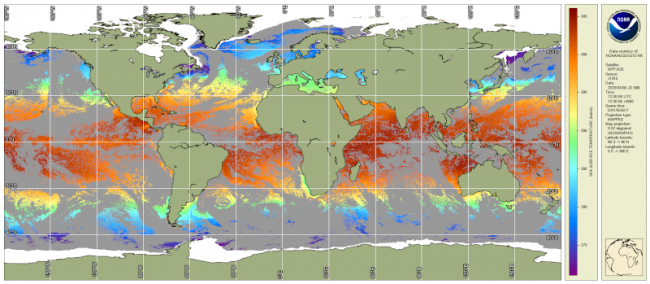
The NOAA Advanced Clear-Sky Processor for Ocean (ACSPO) L3S-LEO is a family of multisensor super-collated (L3S) gridded 0.02º resolution SST products from low earth orbit (LEO) satellites. The L3S-LEO family is organized into three lines: PM, AM and Daily. The AM (mid-morning orbit) and PM (afternoon orbit) lines contain SST data from satellites with 9:30am/pm and 1:30am/pm equator crossing times, respectively. Both AM and PM lines are split into day-time (solar zenith angle < 90º) and night-time (solar zenith angle >= 90º) files, resulting in 4 files per day in total, which approximately cover the 24 hours diurnal cycle in 4 points. The Daily (DY) line combines PM and AM (day and night) SSTs into a single daily L3S SST that is normalized to 1:30am viewing conditions using a statistical model informed by surface wind speed and shortwave radiation.
The AM product is produced from three (currently two active) AVHRR FRACs (flown aboard METOP-A, B and C). The PM product is produced from three VIIRSs (flown aboard NPP, N20, N21) and MODIS (onboard Aqua; included until Dec 31 2022). The DY product is produced by combining all four L3S-LEO-AM/PM day/night SSTs. SST from Terra MODIS is also included in DY in until 31 Dec 2021.
All L3S-LEO products contain information about thermal fronts, which is included in ACSPO files in two new variables ‘sst_front_position’ and ‘sst_gradient_magnitude’. The first variable is a binary indicator of SST front position. It is set to ‘1’ where a front is present, and to ‘0’ elsewhere. The second variable is the SST gradient magnitude (in units of K/km).
L3S-LEO data are provided in GHRSST Data Specification v2 (GDS2) NetCDF format, as L3S (gridded, super-collated, 0.02º). We plan to create an L3S-GEO line, and eventually consolidate the L3S-LEO and L3S-GEO into one sensor-agnostic L3S SST product.
All ACSPO L3S-LEO products provided here are mature and validated. Please contact the CoastWatch helpdesk with any questions.
Product Details
| Short Names |
ACSPO-L3S-LEO-PM-v2.81
ACSPO-L3S-LEO-AM-v2.80
ACSPO-L3S-LEO-Daily-v2.81
|
|---|---|
| Temporal Start Date |
February 24, 2000
|
| Product Families |
Sea Surface Temperature
|
| Measurements |
Sea Surface Temperature - Polar-orbiting
|
| Processing Levels |
Level 3
|
| Latency Groups |
0 Hours <= 24 Hours (NRT)
|
| Latency Details |
24 hours |
| Spatial Resolution Groups |
2km+
|
| Spatial Resolution Details |
0.02° |
| Data Providers |
NOAA
NESDIS
STAR
|
Spatial Coverage
Global
| Description |
180W - 180E |
|---|
Processing Algorithms
ACSPO
| Description |
Advanced Clear Sky Processor for Ocean (ACSPO) is the NOAA Enterprise SST system |
|---|
Platforms
Instruments
Documentation
Algorithms
- Jonasson, O.; Gladkova, I.; Ignatov, A. Towards global daily gridded super-collated SST product from low earth orbiting satellites (L3S-LEO-Daily) at NOAA. Proc. SPIE 2022, 12118, 1211805, doi:10.1117/12.2620103, [pdf paper (link)], [mp4 presentation (link)], [ppt presentation (link)].
- Jonasson, O.; Gladkova, I.; Ignatov, A.; Kihai, Y. Algorithmic Improvements and Consistency Checks of the NOAA Global Gridded Super-Collated SSTs from Low Earth Orbiting Satellites (L3S-LEO). Proc. SPIE 2021, 11752, 1175202, doi:10.1117/12.2585819, [pdf paper (link)], [mp4 presentation (link)], [ppt presentation (link)].
- Jonasson, O.; Gladkova, I.; Ignatov, A.; Kihai, Y. Progress with Development of Global Gridded Super-Collated SST Products from Low Earth Orbiting Satellites (L3S-LEO) at NOAA. Proc. SPIE 2020, 11420, 1142002. doi:10.1117/12.2551819. [pdf paper (link)], [mp4 presentation (link)], [ppt presentation (link)].
- Gladkova, I.; Ignatov, A.; Pennybacker, M.; Kihai, Y. Towards High-Resolution Multi-Sensor Gridded ACSPO SST Product: Reducing Residual Cloud Contamination. Proc. SPIE 2019, 11014, 110140L. doi:10.1117/12.2518462, [pdf paper (link)], [ppt presentation (link)].
- Gladkova, I., A. Ignatov, M. Pennybacker, Y. Kihai, 2019: Towards High-Resolution Multi-Sensor Gridded ACSPO L3S SST Product. GHRSTT XX: Science Team Meeting, June 2019, Frascati, Italy [ppt presentation (link)].
Monitoring
- SQUAM: Dash, P., A. Ignatov, Y. Kihai, J. Sapper, 2010: The SST Quality Monitor (SQUAM). JTech, 27, 1899-1917, doi:10.1175/2010JTECHO756.1.
- iQuam: Xu, F., A. Ignatov, 2014: In situ SST Quality Monitor (iQuam). JTech, 31, 164-180, doi:10.1175/JTECH-D-13-00121.1.
- ARMS: Ding, Y., A. Ignatov, K. He, I. Gladkova, 2018: ACSPO Regional Monitor for SST (ARMS). GHRSTT XIX: Science Team Meeting, June 2018, Darmstadt, Germany [ppt presentation 21.5Mb (link)].
- MICROS: Liang, X., A. Ignatov, 2011: Monitoring of IR Clear-sky Radiances over Oceans for SST (MICROS). JTech, 28, 1228-1242, doi:10.1175/JTECH-D-10-05023.1.
Citation
The ACSPO L3S-LEO SST data are provided by NOAA STAR. We strongly recommend contacting Olafur.Jonasson@noaa.gov or Alex.Ignatov@noaa.gov, before the data are used for any publication or presentation.