AVHRR

Description

Advanced Very High Resolution Radiometer

Platforms
Instrument Types
Imager
Organizations
NOAA

Oceanic Heat Content, Mixed Layer Depth and Depths of 20°C and 26°C Isotherms

Product Families
Ocean Heat Content
Summary

Oceanic Heat Content (OHC) is the measure of the integrated vertical temperature from the sea surface to the depth of the 26°C isotherm and computed from the altimeter-derived isotherm depths in the upper ocean relative to 20°C.  Global 0.25 degree grids are generated daily for OHC, mixed layer depth and depths of 20°C and 26°C isotherms for 3 ocean basins:  North Atlantic, North Pacific and South Pacific 

AVHRR (MetOp-1/2) Level 2/3

Product Families
Sea Surface Temperature
Summary

NOAA CoastWatch / OceanWatch / PolarWatch produces Level 2/3 sea surface temperature datasets using AVHRR sensors aboard the Metop 1/2 satellites. 

NOAA Geo-Polar Blended Global Sea Surface Temperature Analysis (Level 4)

Product Families
Sea Surface Temperature
Summary

The NOAA geo-polar blended SST is a daily 0.05° (~5km) global high resolution satellite-based sea surface temperature (SST) Level-4 analyses generated on an operational basis. This analysis combines SST data from US, Japanese and European geostationary infrared imagers, and low-earth orbiting infrared (U.S. and European) SST data, into a single high-resolution 5-km product.  The three flavors of blended SST products are night only; day/night, and diurnal warming. 

ACSPO Global SST from AVHRR GAC

Product Families
Sea Surface Temperature
Summary

AVHRR GAC Reanalysis 2 (RAN2) dataset is an improved and extended version of AVHRR GAC RAN1 (Ignatov et al., 2016). RAN2 is produced from 5 AVHRR/2s (onboard N07/09/11/12/14) and 5 AVHRR/3s (N15/16/17/18/19) using the NOAA Advanced Clear-Sky Processor for Ocean (ACSPO) enterprise system v2.81. At the time of release, it covers from 1 Sep 1981 to 31 Dec 2021 and will be periodically extended as new L1b data from N15/18/19 arrive. Out of ten satellites, seven (N07/09/11/14/16/18/19) were initially launched into afternoon orbits (1:30pm/am), two (N12/15) into early-morning orbits (7:30pm/am), and one (N17) into mid-morning orbit (10am/pm). All NOAA orbits are not controlled and evolve in time. The RAN2 dataset is documented in (Petrenko et al. 2020 and 2021; Pryamitsyn et al. 2020)

ACSPO Global SST from AVHRR FRAC

Product Families
Sea Surface Temperature
Summary

The AVHRR FRAC SST data are produced from AVHRR/3s onboard Metop-A, -B and -C satellites using the NOAA Advanced Clear-Sky Processor for Ocean (ACSPO) v2.80 enterprise system, described in (Ignatov et al., 2016). Currently, near-real time (NRT) L2P and  0.02° L3U (gridded uncollated) data for Metop-A, -B and -C is produced at STAR (with ~2 to 6hrs latency). The data are being archived at PO.DAAC, and also available at this CoastWatch page as a 2 weeks rotated buffer. Metop-A mission officially ended at 2021-11-15 and the production of the ACSPO SST for the Metop-A ended at 2021-11-14 due to data degradation on 2021-11-15. 
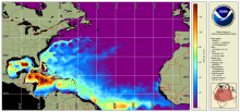
NOAA CoastWatch co-gridded VIIRS SST from ACSPO

Product Families
Sea Surface Temperature
Summary

NOAA CoastWatch co-gridded VIIRS SST products are Level 3 daily composites in compatible format and projection with other CoastWatch Level 3 sector and global products (such as CoastWatch sector VIIRS ocean color).  Twenty four CoastWatch sector files mapped to equatorial projection that cover the globe (see Description tab for sector definitions) two polar stereographic sectors in 750 m nominal, native resolution and a global, 4 km resolution, single file mapped product is also available. These CoastWatch Level 3 products are generated from ACSPO L2P SST as input.

ACSPO Global 0.02º Gridded Super-collated SST and Thermal Fronts from Low-Earth-Orbiting Platforms (L3S-LEO)

Product Families
Sea Surface Temperature
Summary

NOAA Advanced Clear-Sky Processor for Ocean (ACSPO) L3S-LEO SST is a family of multisensor gridded ("L3") 0.02º resolution super-collated ("S") products. The L3S-LEO family is organized into three lines: PM, AM and Daily. The AM and PM lines correspond to 9:30am/pm and 1:30am/pm equator crossing times, respectively. The Daily line combines PM and AM (day and night) SSTs into a single daily L3S SST that is normalized to 1:30am viewing conditions.