The NOAA NCEI Blended Seawinds (NBS) version 2.0 dataset synthesizes observations from multiple satellites (up to seven satellites since June 2002) to create gridded wind speeds (10m, neutral). This is an updated version of the existing NOAA NBS v1.0, which is a global gridded 0.25° and 6-hourly sea surface winds product that has wide applications in marine transportation, marine ecosystem and fisheries, offshore winds, weather and ocean forecasts, and other areas.
Data Access
Product Overview
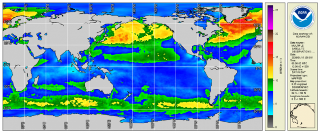
The NOAA NCEI Blended Seawinds (NBS) version 2.0 dataset synthesizes observations from multiple satellites (up to seven satellites since June 2002) to create gridded wind speeds . This is an updated version of the existing NOAA NBS v1.0, which is a global gridded 0.25° and 6-hourly sea surface winds product that has wide applications in marine transportation, marine ecosystem and fisheries, offshore winds, weather and ocean forecasts, and other areas. Blending the data from multiple satellites fills in the temporal and spatial data gaps present in each source dataset, and reduces subsampling aliases and random errors. These satellites include scatterometers and microwave radiometers/imagers, which do not provide accurate observations of intensive high-speed hurricane winds because their signals saturate in very high winds or degrade in the presence of rain.
Recent advancements in satellite wind retrievals revealed that the L-band (1.42 GHz) instrument on the Soil Moisture Active Passive (SMAP) satellite and the AMSR2 All-Weather channel (~6.9 GHz) can provide accurate hurricane winds of up to 65 m/s (145 MPH) without being affected by rain; these data are incorporated in a new version of the Blended Sea Winds, NBS v2.0, using a multi-sensor data fusion technique based on random errors, enabling it to resolve very high winds, especially along the eyewalls of tropical cyclones and hurricanes. NBS v2.0 provides both a long-term record of >30 years retrospectively since July 1987 and a near-real-time (NRT) mode with 1-day latency. With the present seven satellites, there are very few data gaps over the global ocean in the 6-hourly interpolated fields, and those gaps are mostly in the higher latitudes (beyond 40°N or S). To produce a version of “gap-free” Level 4 wind data, the few remaining gaps are filled with the ERA-5 reanalysis winds in the delayed mode NBS (latency and cycle of a month) and with NOAA/NCEP/GFS forecast winds in the NRT version. The reanalysis or forecast data are also used to calculate the wind directions, which is essential to retrieve wind and wind stress components.
These products were developed in response to the increasing demand for higher resolution global datasets, and can be used to improve the accuracy of ocean and weather conditions forecasts. Please contact ncei.satellite.ocean.internal@noaa.gov for more information about these products.
Product Details
| Temporal Start Date |
September 7, 1987
|
|---|---|
| Product DOI | |
| Temporal Coverage |
Temporal: 6 hour, 1 day, 1 month; beginning July 1987 |
| Product Families |
Sea Surface Winds
|
| Measurements |
Sea Surface Vector Winds
|
| Processing Levels |
Level 4
|
| Latency Groups |
0 Hours <= 24 Hours (NRT)
24+ hours (Delayed)
|
| Latency Details |
24 hrs (for NRT) |
| Spatial Resolution Groups |
2km+
|
| Spatial Resolution Details |
0.25° |
| Data Providers |
NOAA
NESDIS
NCEI
STAR
|
Spatial Coverage
Global
| Description |
180W - 180E |
|---|
Platforms
Instruments
Documentation
- Saha, K.; Huai-Min, Z. Hurricane and Typhoon Storm Wind Resolving NOAA NCEI Blended Sea Surface Wind (NBS) Product. Frontiers in Marine Sciences – Ocean Observation 2022, 9, 1–12. https://doi.org/10.3389/fmars.2022.935549.
- Peng, G., H.-M. Zhang, H.P. Frank, J.-R. Bidlot, M. Higaki, S. Stevens, and W.R. Hankins, 2013: Evaluation of various surface wind products with OceanSITES buoy measurements. Weather and Forecasting, 28, 1281–1303, https://doi.org/10.1175/WAF-D-12-00086.1.
- Zhang, H.-M., J. J. Bates, and R. W. Reynolds, 2006: Assessment of composite global sampling: Sea surface wind speed, Geophysical Research Letters, 33, L17714, https://doi.org/10.1029/2006GL027086.
- Zhang, H.-M., R.W. Reynolds, and J.G. Bates, 2006: Blended and gridded high resolution global sea surface wind speed and climatology from multiple satellites: 1987–present. 14th Conference on Satellite Meteorology and Oceanography, Atlanta, GA, American Meteorological Society, Paper 100004. [https://ams.confex.com/ams/Annual2006/webprogram/Paper100004.html].
Citation
Saha, K.; Huai-Min, Z. Hurricane and Typhoon Storm Wind Resolving NOAA NCEI Blended Sea Surface Wind (NBS) Product. Frontiers in Marine Sciences – Ocean Observation 2022, 9, 1–12. https://doi.org/10.3389/fmars.2022.935549.