Sea Surface Winds

Sea Surface Winds also known as Ocean Surface Vector Winds (OSVW) for some techniques

Winds, both magnitude (speed) and direction over the ocean drive other physical and chemical processes and so are used to model dynamic earth/ocean/atmosphere coupled systems ocean and are used for marine weather forecasting. Different remote sensing techniques may be used for gathering information on ocean surface winds including active radar and passive microwave

NOAA NCEI Blended Seawinds (NBS v2)

Product Families
Sea Surface Winds
Summary

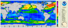
The NOAA NCEI Blended Seawinds (NBS) version 2.0 dataset synthesizes observations from multiple satellites (up to seven satellites since June 2002) to create gridded wind speeds (10m, neutral). This is an updated version of the existing NOAA NBS v1.0, which is a global gridded 0.25° and 6-hourly sea surface winds product that has wide applications in marine transportation, marine ecosystem and fisheries, offshore winds, weather and ocean forecasts, and other areas. 

Vector Winds OSCAT-2 SCATSAT-1

Product Families
Sea Surface Winds
Summary

Ocean Surface Vector Winds (OSVW; magnitude and direction) from the Ocean Scatterometer (OSCAT) on SCATSAT-1.

Vector Winds ASCAT Metop-A/B/C

Product Families
Sea Surface Winds
Summary

Ocean Surface Vector Winds (OSVW; magnitude and direction) from the Advanced Scatterometer (ASCAT) on Metop-A, Metop-B, and Metop-C.  Metop-A was decommissioned November 15, 2021.

Synthetic Aperture Radar (Surface Roughness) Winds

Product Families
Sea Surface Roughness
Sea Surface Winds
Summary

Spaceborne Synthetic Aperture Radar (SAR) imagery maps the surface microwave radar reflectivity at resolutions from a sub-meter to 100 m depending on the particular SAR satellite and mode. Since a radar provides its own illumination, imagery is independent of the time of day. At typical radar frequencies, SARs can image through clouds, so SARs are considered "all-weather" instruments.  Several geophysical parameters can be derived from SAR including sea surface wind speed.

Along-track significant wave height, wind speed and sea level anomaly from multiple altimeters

Product Families
Sea Surface Height
Sea Surface Winds
Summary

The NOAA Laboratory for Satellite Altimetry's (LSA) sea surface height team produces 0.25-degree longitude/latitude Level-3 significant wave height, wind speed, and sea level anomaly (SLA) daily datasets by applying optimal interpolation to along-track satellite observations over the global ocean from a constellation of radar altimeter missions. Theses grids are produced with near-real time (3-5 hour latency) data.

OceanWatch Monitor

Monitor Type
Data Assurance
Quality Assurance
Description

This OceanWatch Monitor provides an easy way for CoastWatch users to assess the state of the available products at one location (under one URL). The current capability includes monitoring of five different environmental data record (EDRs): Ocean Color (OC) Chlorophyll-a, Sea Surface Height (SSH), Sea Surface Salinity (SSS), Sea Surface Temperature (SST) and Sea Surface Wind (SSW) aka Ocean Surface Vector Wind. The OM framework is flexible to accommodate newer products for existing EDRs, and scalable for adding a newer EDR. Besides product monitoring within a given EDR family, it is envisioned to allow a joint analysis of different EDRs under an inter-thematic module. However, not all available CW products have been included in the monitor yet and this will be done incrementally. Likewise, the various data sets may have different latencies depending on their scientific needs.  See Quickstart Userguide for more information.

CoastWatch Data Quality & Availability Dashboard

Monitor Type
Data Assurance
Quality Assurance
Description

This Data Availability Dashboard gives a concise report of product availability and a quick look at a bulk time series to monitor for product stability