Level 2

Level-2 data products are derived geophysical variables at the same resolution and locations as the level 1 source data. 

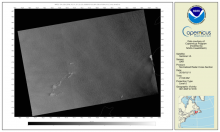
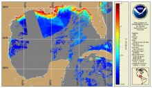
SAR Composite Arctic Imagery (normalized radar cross section)

Product Families
Sea Surface Roughness
Summary

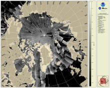
The daily composite of Synthetic Aperture Radar (SAR) Normalized Radar Cross Section (NRCS) imagery covering the Arctic and sub-Arctic maritime regions over a period of one day are available at 1-km resolution. These high-resolution, weather- and time-agnostic measurements of surface backscatter contain detailed information tailored for sea ice classification purposes.

Synthetic Aperture Radar Imagery (NRCS)

Product Families
Sea Surface Roughness
Summary

Spaceborne Synthetic Aperture Radar (SAR) imagery maps the surface microwave radar reflectivity at resolutions from a sub-meter to 100 m depending on the particular SAR satellite and mode. Since a radar provides its own illumination, imagery is independent of the time of day. At typical radar frequencies, SARs can image through clouds, so SARs are considered "all-weather" instruments.  Several gephysical parameters can be derived from SAR including sea surface wind speed.

Synthetic Aperture Radar (Surface Roughness) Winds

Product Families
Sea Surface Roughness
Sea Surface Winds
Summary

Spaceborne Synthetic Aperture Radar (SAR) imagery maps the surface microwave radar reflectivity at resolutions from a sub-meter to 100 m depending on the particular SAR satellite and mode. Since a radar provides its own illumination, imagery is independent of the time of day. At typical radar frequencies, SARs can image through clouds, so SARs are considered "all-weather" instruments.  Several geophysical parameters can be derived from SAR including sea surface wind speed.

AVHRR (MetOp-1/2) Level 2/3

Product Families
Sea Surface Temperature
Summary

NOAA CoastWatch / OceanWatch / PolarWatch produces Level 2/3 sea surface temperature datasets using AVHRR sensors aboard the Metop 1/2 satellites. 

ACSPO Global SST from VIIRS

Product Families
Sea Surface Temperature
Summary

These VIIRS SST data are produced using the NOAA Advanced Clear-Sky Processor for Ocean (ACSPO) SST system, from the afternoon NPP, N20 and N21 satellites, in two formats: L2P and L3U (uncollated). The data are reported in 10 min granule files in NetCDF4 format, compliant with the GHRSST Data Specifications v2 (GDS2). For each satelite, there are 144 granules per 24 hr interval, with a total data volume of ~7.1 GB/day for L2P, and ~0.4 GB/day for L3U.

ACSPO Global SST from AVHRR GAC

Product Families
Sea Surface Temperature
Summary

AVHRR GAC Reanalysis 2 (RAN2) dataset is an improved and extended version of AVHRR GAC RAN1 (Ignatov et al., 2016). RAN2 is produced from 5 AVHRR/2s (onboard N07/09/11/12/14) and 5 AVHRR/3s (N15/16/17/18/19) using the NOAA Advanced Clear-Sky Processor for Ocean (ACSPO) enterprise system v2.81. At the time of release, it covers from 1 Sep 1981 to 31 Dec 2021 and will be periodically extended as new L1b data from N15/18/19 arrive. Out of ten satellites, seven (N07/09/11/14/16/18/19) were initially launched into afternoon orbits (1:30pm/am), two (N12/15) into early-morning orbits (7:30pm/am), and one (N17) into mid-morning orbit (10am/pm). All NOAA orbits are not controlled and evolve in time. The RAN2 dataset is documented in (Petrenko et al. 2020 and 2021; Pryamitsyn et al. 2020)

ACSPO Global SST from AVHRR FRAC

Product Families
Sea Surface Temperature
Summary

The AVHRR FRAC SST data are produced from AVHRR/3s onboard Metop-A, -B and -C satellites using the NOAA Advanced Clear-Sky Processor for Ocean (ACSPO) v2.80 enterprise system, described in (Ignatov et al., 2016). Currently, near-real time (NRT) L2P and  0.02° L3U (gridded uncollated) data for Metop-A, -B and -C is produced at STAR (with ~2 to 6hrs latency). The data are being archived at PO.DAAC, and also available at this CoastWatch page as a 2 weeks rotated buffer. Metop-A mission officially ended at 2021-11-15 and the production of the ACSPO SST for the Metop-A ended at 2021-11-14 due to data degradation on 2021-11-15. 

ACSPO Global SST from AHI

Product Families
Sea Surface Temperature
Summary

The AHI SST data are produced from Himawari-9 (Himawari-8 before 2022-Dec-13) geostationary satellite using the NOAA Advanced Clear-Sky Processor for Ocean (ACSPO) v2.90 enterprise system,(ACSPO v2.70 was used for Himawari-8). Currently, only near-real time (NRT) data are produced at STAR, with a 2-6 hour latency (typically closer to 2 hours). The data are available in NetCDF4 format, compliant with the GHRSST Data Specifications v2 (GDS2). The data for Himawari-8 was archived with PO.DAAC with start date 2019-Oct-16 and end date 2022-Dec-13. The full mission of the Himawari-9 has been archiving in PO.DAAC. The data for Himawari-9 is also available at this Coast Watch page as a 2week rotated buffer.  The reanalysis of the full mission of the Himawari-8 is available at this Coast Watch page. There is a plan to reprocess the AHI data, for the full Himawari-9 missions.

ACSPO Global SST from ABI

Product Families
Sea Surface Temperature
Summary

The ABI SST data are produced from GOES-East (GOES-16) and GOES-West (at present GOES-18, before 2023/01/10 GOES-17) satellite using the NOAA Advanced Clear-Sky Processor for Ocean (ACSPO) v2.xx enterprise system. Currently, near-real time (NRT) data are produced at STAR, with a ~2-6 hour latency. A Reanalysis (RAN) dataset for GOES-16 is also available. The data are available in NetCDF4 format, compliant with the GHRSST Data Specifications v2 (GDS2). Currently, the data are archived on PO.DAAC and available at this Coast Watch page as a 2week rotated buffer.

Along-track significant wave height, wind speed and sea level anomaly from multiple altimeters

Product Families
Sea Surface Height
Sea Surface Winds
Summary

The NOAA Laboratory for Satellite Altimetry's (LSA) sea surface height team produces 0.25-degree longitude/latitude Level-3 significant wave height, wind speed, and sea level anomaly (SLA) daily datasets by applying optimal interpolation to along-track satellite observations over the global ocean from a constellation of radar altimeter missions. Theses grids are produced with near-real time (3-5 hour latency) data.

NOAA MSL12 Ocean Color - Science Quality - VIIRS SNPP

Product Families
Ocean Color
Summary

VIIRS Science Quality Ocean Color Level 2 (EDR) is produced by NOAA/STAR Ocean Color Team through NOAA Multi-Sensor Level 1 to Level 2 processing system (MSL12) using an improved calibration for the satellite data record (OC-SDR, which is Level 1b).  CoastWatch Level-3 composites, binned and mapped data products also available.

NOAA MSL12 Ocean Color - Near Real Time - VIIRS single-sensor SNPP and NOAA-20

Product Families
Ocean Color
Summary

Ocean Color Level 2 (EDR) is produced through NOAA Multi-Sensor Level 1 to Level 2 processing system (MSL12) from IDPS satellite data record (SDR, Level 1b).  Level 3 mapped and composite products are also available, now including a 2-sensor (VIIRS:  SNPP plus NOAA-20) merged daily chlorophyll and diffuse attenuation coefficients (Kd(490) and Kd(PAR) .