Ecosystem Monitoring
New experimental mesoscale eddy products
Announcement

The sea surface height team in NOAA’s Laboratory for Satellite Altimetry developed two experimental mesoscale eddy products:
Multiparameter Eddy Significance Index (MESI)
MUltiparameter NRT System for Tracking Eddies Retroactively (MUNSTER)
Hardware issues result in inaccessible data
Announcement

Data access has been restored.
Sea surface temperature processing issues
Announcement

Sea surface temperature processing of ACSPO FRAC L2P/L3U and L3S products has been suspended due to ongoing maintenance beginning August 12, 2024.
Monitoring water clarity on Cape Cod with satellite imagery: CoastWatch-led study
User Story

CoastWatch researchers recently collaborated with scientists in Massachusetts to study the feasibility of using satellite data to monitor water clarity in Cape Cod.
New Hurricane Tool in Development
Announcement
AOML, CIMAS, and CoastWatch have developed an initial version of a hurricane-ocean database and display for all Atlantic tropical cyclones during 2003-2022
Upcoming ACSPO SST Filename change
Announcement
The NOAA Advanced Clear-Sky Processor for Ocean (ACSPO) L3S-LEO-PM and L3S-LEO-DY products will be updated from ACSPO v2.80 to ACSPO v2.81 on October 2, 2023.
The updates from V2.80 are:
NOAA-21 reaches Provisional Maturity for SST
Announcement
The Joint Polar Satellite System (JPSS) has approved NOAA-21 Visible Infrared Imaging Radiometer Suite (VIIRS) Advanced Clear Sky Processor for Ocean (ACSPO) sea surface temperature (SST) products for Provisional Maturity
Sargassum FAQ
User Story
A Frequently Asked Questions (FAQs) for Sargassum was composed by the NOAA Atlantic Oceanographic & Meteorological Laboratory (AOML) in partnership with NOAA CoastWatch Caribbean, Gulf of America, and Atlantic OceanWatch Node.

Juvenile Salmon Shark Habitat Use Research
User Story

Standings of small juvenile salmon sharks have been reported between British Columbia, Canada and northern Baja California. A recent study used CoastWatch sea surface temperature data from the west coast regional node to explore the link between salmon shark strandings and water temperature.
Harmful Algal Bloom Monitoring and Forecasting in the Gulf of America
User Story

NOAA's National Ocean Service uses Coast Watch ocean color data along with cell counts and other environmental information to produce a Harmful Algal Blooms Observing System (HABSOS) and a Harmful Algal Bloom Operational Forecast System (HAB-OFS)
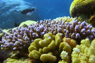
Ocean acidification in the Caribbean
User Story

In collaboration with the NOAA Atlantic Oceanographic and Meteorological Laboratory's Ocean Chemistry and Ecosystems Division and NOAA Coral Reef Watch, the Caribbean/Gulf of America node of CoastWatch produces an ocean acidification product suite for the greater Caribbean region to track changes in the surface ocean that can be used as an important tool in coral reef research and management.
2022 Status of U.S. Marine and Great Lakes Ecosystems Released
Announcement
The Ecosystem Indicator Working Group (EIWG) has released an update of the National Marine Ecosystem Status website, which provides easy access to NOAA’s wide range of important coastal and marine ecosystem data. The website provides a holistic view of important ecosystem data and has been newly expanded to the Great Lakes in 2022. New indicators such as the number of days an ecosystem experiences a marine heatwave and changes in the distribution of species have also been added.
A Satellite's View of Coastal Erosion
User Story
One expected impact of climate change is an increase in the frequency and severity of storms in the eastern United States. As such, many coastal communities and ecosystems are increasingly vulnerable to the detrimental impacts of coastal erosion. The CoastWatch East Coast node monitors coastal erosion by tracking in-water sediment values.
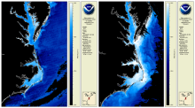
Detecting Sea Level Anomalies with Satellites
User Story
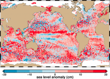
By studying sea level anomalies, scientists can improve understanding of ocean circulation patterns and improve forecasts of climatological events such as El Niño and La Niña. The NOAA Laboratory for Satellite Altimetry produces daily near-real time global sea level anomaly datasets from a constellation of radar altimeter missions.
Improving Satellite Sea Surface Temperature Analysis
User Story
Information about sea surface temperature is important for weather and ocean forecasting, climate monitoring, military and defense operations, ecosystem assessment, fisheries analyses and tourism operations. NOAA's Sea Surface Temperature Team is working to improve their products by reanalyzing past data with NOAA's Advanced Clear-Sky Processor for Oceans (ACSPO) using the enterprise algorithm.
Colors and Confusion: Making Better Color Choices for Data Visualization
User Story
Communication of scientific information and data to the public is part of NOAA’s mission, and scientific visualization is often the public’s first encounter with the agency’s data. This post gives an overview of recent advances and considerations for selecting and improving color selection for remote sensing data. NOAA CoastWatch will be experimenting with different colors for its data presentations.
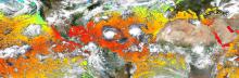
Saharan Dust and its Impacts
User Story

Winds blowing across the Sahara Desert send large clouds of dust that travel thousands of miles to the Atlantic Ocean or Mediterranean Sea. The growth of phytoplankton, microscopic plants at the base of the ocean food chain, is restricted by iron availability. When Saharan dust is blown into the ocean, phytoplankton use the iron and nutrients from the dust and begin to grow and reproduce.
Temperature Climate Indicators of Estuaries
User Story
The National Estuary Program identifies, protects, and conserves water quality for ecologically significant estuaries and surrounding watersheds. The National Estuary Program uses Sea Surface Temperature time series products produced by the NOAA CoastWatch East Coast Node for estuary management.
Atlantic OceanWatch Assisting FEMA as Sargassum Reaches Record Levels in Caribbean
User Story
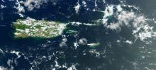
Node Managers Dr. Goni and Dr. Trinanes are participating in the USVI/Sargassum Emergency FEMA Workshop in St. Croix
Predicting Vibrio Risk Using Satellite Data
User Story
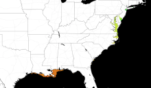
As sea temperatures rise, lethal Vibrio bacteria species populations are growing. The NOAA CoastWatch Caribbean and Gulf of America regional node at AOML has developed a model to predict Vibrio habitat suitability on a global scale.
CoastWatch Tools and Data Featured in Undergraduate Courses
User Story
Dr. Sherry Palacios from CSUMB utilizes CoastWatch ERDDAP, Data Portal, and training materials in her oceanography curricula.
India Oliver - Undergraduate Student
Student Spotlight
This summer, NOAA CoastWatch/OceanWatch/PolarWatch hosted undergraduate summer intern, India Oliver, as part of an undergraduate scholarship program run through NOAA’s Educational Partnership Program with Minority Serving Institutions.
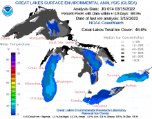
Predicting Lake Ice Drifts in Cleveland
User Story
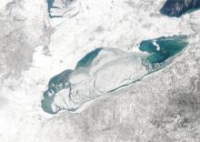
Meteorologists at the Cleveland Weather Forecast Office tell a story exemplifying how CoastWatch data supports their mission, and how accurate predictions can save lives.
Predicting Winter Weather in Michigan
User Story
Forecasters at the Grand Rapids Weather Forecast Office describe how they use CoastWatch data to predict lake effect snow, freezing spray, and more.
| 2025-11-21 | Switch from Himawari-8 to Himawari-9 |
| 2025-09-11 | Possible disruptions in ASCAT wind and SEVIRI SST products |
| 2025-08-20 | NOAA CoastWatch Sentinel-1C data availability |
| 2025-06-17 | Product Availability |