Climate & Weather
New experimental mesoscale eddy products
Announcement

The sea surface height team in NOAA’s Laboratory for Satellite Altimetry developed two experimental mesoscale eddy products:
Multiparameter Eddy Significance Index (MESI)
MUltiparameter NRT System for Tracking Eddies Retroactively (MUNSTER)
Sea surface temperature processing issues
Announcement

Sea surface temperature processing of ACSPO FRAC L2P/L3U and L3S products has been suspended due to ongoing maintenance beginning August 12, 2024.
Changes in Ocean Heat Content products
Announcement
The Ocean Heat Content product produced by the Office of Satellite Products and Operations has been updated for cloud processing resulting in a change to the filename and underlying metadata.
New Hurricane Tool in Development
Announcement
AOML, CIMAS, and CoastWatch have developed an initial version of a hurricane-ocean database and display for all Atlantic tropical cyclones during 2003-2022
Upcoming ACSPO SST Filename change
Announcement
The NOAA Advanced Clear-Sky Processor for Ocean (ACSPO) L3S-LEO-PM and L3S-LEO-DY products will be updated from ACSPO v2.80 to ACSPO v2.81 on October 2, 2023.
The updates from V2.80 are:
NOAA-21 reaches Provisional Maturity for SST
Announcement
The Joint Polar Satellite System (JPSS) has approved NOAA-21 Visible Infrared Imaging Radiometer Suite (VIIRS) Advanced Clear Sky Processor for Ocean (ACSPO) sea surface temperature (SST) products for Provisional Maturity
Update/change to NCEI Blended Winds product metadata
Announcement
The NCEI Blended Winds product metadata has been updated. Please review these changes.
Ocean acidification in the Caribbean
User Story

In collaboration with the NOAA Atlantic Oceanographic and Meteorological Laboratory's Ocean Chemistry and Ecosystems Division and NOAA Coral Reef Watch, the Caribbean/Gulf of America node of CoastWatch produces an ocean acidification product suite for the greater Caribbean region to track changes in the surface ocean that can be used as an important tool in coral reef research and management.
The Tongue of the Ocean
User Story
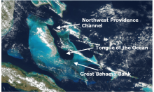
The Tongue of the Ocean is a deep water basin in the Bahamas that is surrounded to the east, west and south by a carbonate bank known as the Great Bahama Bank. The deep blue water of the Tongue is a stark contrast to the shallow turquoise waters of the surrounding Bank.
A Satellite's View of Coastal Erosion
User Story
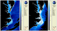
One expected impact of climate change is an increase in the frequency and severity of storms in the eastern United States. As such, many coastal communities and ecosystems are increasingly vulnerable to the detrimental impacts of coastal erosion. The CoastWatch East Coast node monitors coastal erosion by tracking in-water sediment values.
Detecting Sea Level Anomalies with Satellites
User Story
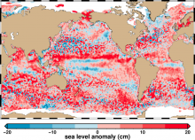
By studying sea level anomalies, scientists can improve understanding of ocean circulation patterns and improve forecasts of climatological events such as El Niño and La Niña. The NOAA Laboratory for Satellite Altimetry produces daily near-real time global sea level anomaly datasets from a constellation of radar altimeter missions.
Improving Satellite Sea Surface Temperature Analysis
User Story
Information about sea surface temperature is important for weather and ocean forecasting, climate monitoring, military and defense operations, ecosystem assessment, fisheries analyses and tourism operations. NOAA's Sea Surface Temperature Team is working to improve their products by reanalyzing past data with NOAA's Advanced Clear-Sky Processor for Oceans (ACSPO) using the enterprise algorithm.
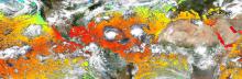
Colors and Confusion: Making Better Color Choices for Data Visualization
User Story
Communication of scientific information and data to the public is part of NOAA’s mission, and scientific visualization is often the public’s first encounter with the agency’s data. This post gives an overview of recent advances and considerations for selecting and improving color selection for remote sensing data. NOAA CoastWatch will be experimenting with different colors for its data presentations.
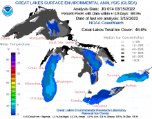
Great Lakes Quarterly Climate Impacts and Outlook
User Story
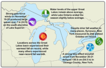
U.S. and Canadian Great Lakes agencies work together to document significant quarterly events, seasonal and yearly changes for the Great Lakes region and compile them into quarterly reports. NOAA Great Lakes CoastWatch data used in these bulletins includes Sea Surface Temperature, Synthetic Aperture Radar and real time marine data from buoys, coastal met stations, airports, and ships.
Tropical Cyclone Heat Potential
User Story
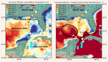
NOAA's Atlantic Oceanography & Meteorological Laboratory produces a Tropical Cyclone Heat Potential (TCHP) product represents a robust measure of how much energy is available in the ocean to sustain or modify the intensity of tropical cyclones.The NOAA CoastWatch Geo-Polar Blended surface sea temperature product and sea surface height data are used to produce global daily TCHP fields.
Temperature Climate Indicators of Estuaries
User Story
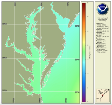
The National Estuary Program identifies, protects, and conserves water quality for ecologically significant estuaries and surrounding watersheds. The National Estuary Program uses Sea Surface Temperature time series products produced by the NOAA CoastWatch East Coast Node for estuary management.
Monitoring Sea Surface Winds and Sea Ice with Satellite Radar
User Story
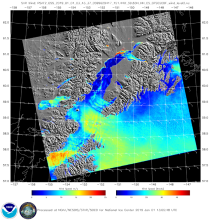
Synthetic Aperture Radar (SAR) is an active radar satellite instrument that transmits microwave pulses that bounce off the Earth’s surface. The radar signals are then processed into imagery that can be used to derive several geographic and non-geographic features including: wind speeds, oil spills, sea ice and ship detection.
NOAA-15 AVHRR Scan Motor Issue
Announcement
NOAA-15 AVHRR scan motor has been having issues. NOAA CoastWatch recommends using other spacecraft and ACSPO products (like the new daily L3S global 2km product) for your sea surface temperature needs.
CoastWatch Tools and Data Featured in Undergraduate Courses
User Story
Dr. Sherry Palacios from CSUMB utilizes CoastWatch ERDDAP, Data Portal, and training materials in her oceanography curricula.
Gulf of America Loop Current
User Story
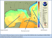
The Gulf of America loop current brings warm Caribbean water northward between the Yucatan Peninsula and Cuba and into the Gulf. The current loops around the Gulf, flows southeastward into the Florida Strait where it serves as a parent to the Florida current and ultimately joins the Gulf Stream.
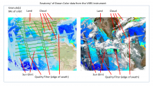
Annotated Ocean Color from VIIRS
Gallery Images
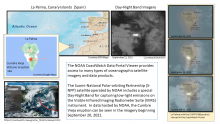
Cumbre Vieja Volcanic Eruption
Gallery Images
Predicting Lake Ice Drifts in Cleveland
User Story
Meteorologists at the Cleveland Weather Forecast Office tell a story exemplifying how CoastWatch data supports their mission, and how accurate predictions can save lives.
Hunga Tonga–Hunga Ha'apai Eruption
Gallery Images
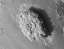
Visible satellite images taken during the Hunga Tonga-Hunga Ha'apai eruption that occured on Jan. 15, 2022.
Predicting Winter Weather in Michigan
User Story
Forecasters at the Grand Rapids Weather Forecast Office describe how they use CoastWatch data to predict lake effect snow, freezing spray, and more.